Latest Mesoscale Discussion: Damaging Winds Possible as Storms Weaken
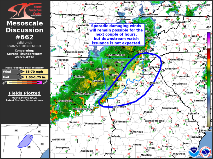
The severe weather threat for Severe Thunderstorm Watch 216 continues. Sporadic damaging winds remain possible as a weakening squall line moves across northern Georgia through the evening. However, with the onset of nighttime cooling, the severe threat should become less widespread and robust. Downstream watch issuance is not expected.
The convective line pushing east across eastern Alabama and northern Georgia has started to show signs of weakening, as indicated by falling echo tops and warming cloud-top temperatures in the latest satellite imagery. This weakening is likely due to the cooler surface temperatures, which have dropped from the upper 70s and low 80s into the low 70s and upper 60s over the past hour or two. While the low-level inversion remains shallow in the early stages of this cooling cycle, enough buoyancy may persist across northern and northeast Georgia, as well as the far western Carolinas, where dewpoints are still in the low to mid 60s. This could allow for a few stronger updraft pulses within the squall line, which may produce damaging winds at the surface. However, the overall threat is expected to decrease as time goes on and as the atmosphere becomes more stable with increasing low-level stability and modest wind shear.
Category: Alabama's Weather, ALL POSTS, Severe Weather, Social Media
About the Author (Author Profile)
Scott Martin is an operational meteorologist, professional graphic artist, musician, husband, and father. Not only is Scott a member of the National Weather Association, but he is also the Central Alabama Chapter of the NWA president. Scott is also the co-founder of Racecast Weather, which provides forecasts for many racing series across the USA. He also supplies forecasts for the BassMaster Elite Series events including the BassMaster Classic.Subscribe
If you enjoyed this article, subscribe to receive more just like it.


