Watch Possible: Damaging Wind Threat Increasing Across Eastern Alabama into Northwest Georgia
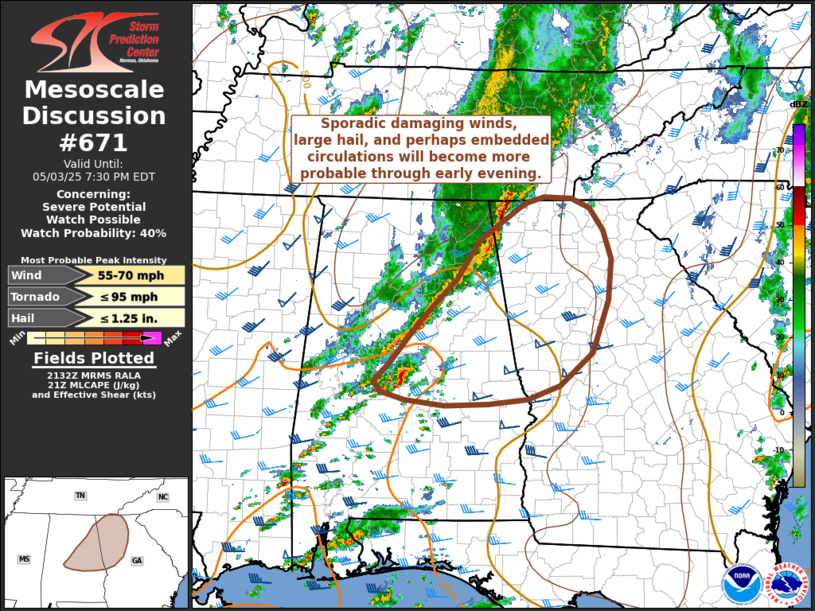
A developing squall line stretching from central into northeast Alabama is beginning to show signs of strengthening this afternoon as it advances eastward toward the Georgia state line. Clearing skies across the region have allowed temperatures to rise into the mid-to-upper 70s, which has weakened surface-based inhibition and boosted instability, with MLCAPE (Most Unstable Convective Available Potential Energy) values now estimated between 500 and 1000 J/kg. This increasing buoyancy, paired with 35 to 40 knots of deep-layer shear, is fostering an uptick in thunderstorm organization and intensity.
Damaging wind gusts will remain the primary threat as these storms move east, especially within stronger bowing segments of the line. However, occasional large hail and perhaps even a brief tornado cannot be ruled out, particularly where embedded circulations develop within segments that become better aligned with low-level shear.
If current trends persist or intensify further, a Severe Thunderstorm or Tornado Watch could be issued for parts of eastern Alabama and northwest Georgia. Residents in these areas should remain weather-aware and prepared to act quickly if warnings are issued later this evening.
Category: Alabama's Weather, ALL POSTS, Severe Weather, Social Media
About the Author (Author Profile)
Scott Martin is an operational meteorologist, professional graphic artist, musician, husband, and father. Not only is Scott a member of the National Weather Association, but he is also the Central Alabama Chapter of the NWA president. Scott is also the co-founder of Racecast Weather, which provides forecasts for many racing series across the USA. He also supplies forecasts for the BassMaster Elite Series events including the BassMaster Classic.Subscribe
If you enjoyed this article, subscribe to receive more just like it.


