Evening Storms Sweep Across East Alabama With Wind, Hail, and Lightning
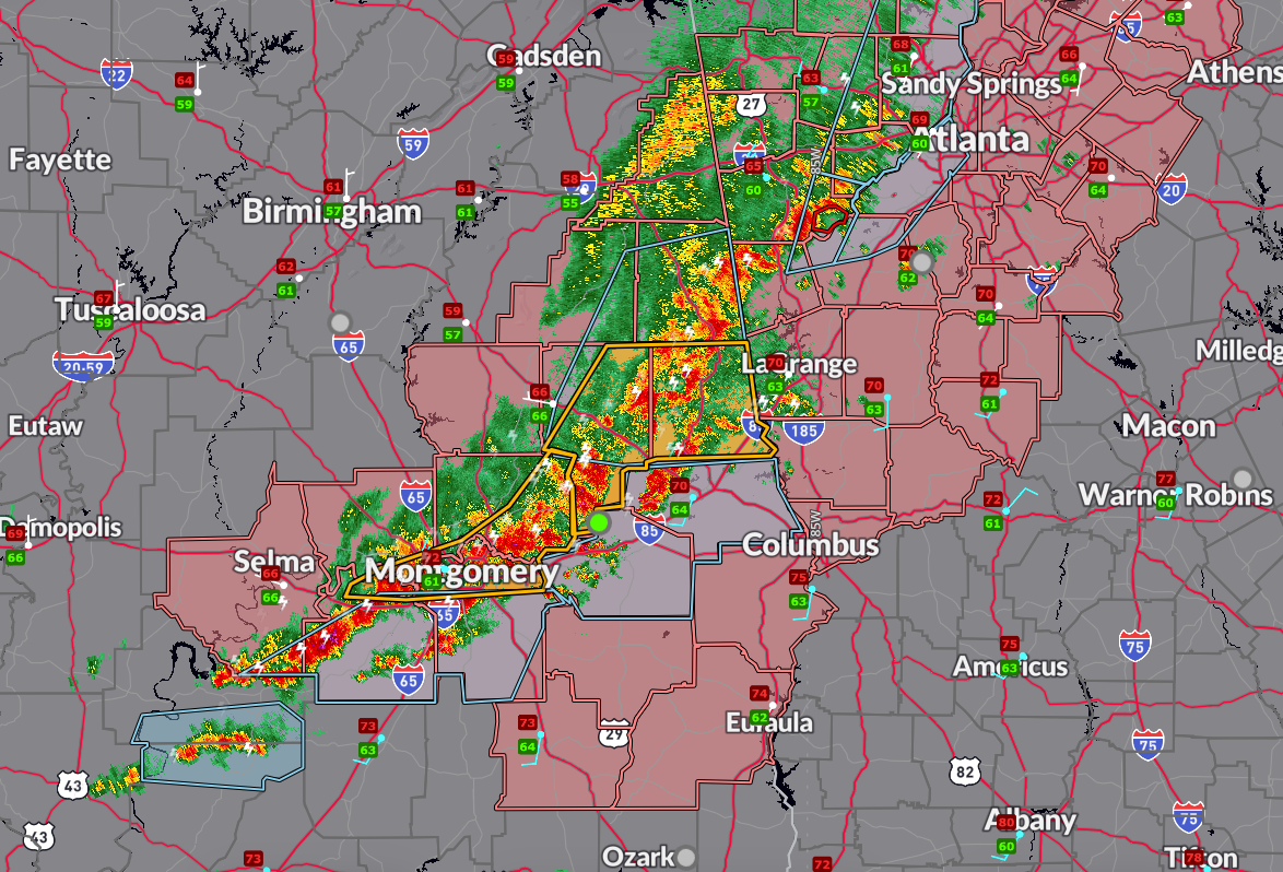
Strong to severe thunderstorms continue pushing eastward across east-central and southeast Alabama this evening as a cold front approaches the I-85 corridor. The severe threat will persist through 9 to 10 PM, particularly across areas in the active Severe Thunderstorm Watch #221, which includes Montgomery, Auburn, Phenix City, Selma, and surrounding communities.
Forecast soundings and radar analysis indicate sufficient instability and deep-layer shear, with hodographs showing around 40 to 45 knots of bulk wind difference, supportive of supercells capable of producing large hail up to 1.75 inches in diameter. However, ongoing storm interactions and clustering may limit the overall coverage of severe storms as the evening progresses.
Radar at 6:30 PM shows a line of strong to severe storms from near Abanda to Lake Martin, and another line from Eclectic to Lowndesboro, all moving east at 25 to 35 mph. These storms are producing wind gusts up to 60 mph and quarter-size hail, along with torrential rainfall and frequent cloud-to-ground lightning. Localized flash flooding is possible, especially in areas where storms repeatedly track over the same location.
A special weather statement is in effect for Montgomery, Lowndes, and southeastern Dallas counties, where wind gusts up to 50 mph and penny-size hail are occurring. This is in addition to the earlier severe thunderstorm warning for Autauga, Elmore, Montgomery, and northern Lowndes counties, which remains in effect until 6:45 PM.
The NWS in Birmingham says they will issue a significant weather advisory for Macon and Lee Counties, instead of a severe thunderstorm warning. Strong thunderstorms are moving southeast at 30 mph into Lee and Macon counties this evening, producing wind gusts up to 40 mph and half-inch hail. In addition to minor hail and wind impacts, torrential rain and frequent lightning may lead to localized flooding in areas like Tuskegee, Beauregard, and Auburn University.
Behind the storms and frontal boundary, an upper low currently over central Missouri will swing south into the Tennessee Valley overnight. This may bring scattered light rain and clouds across north Alabama tonight and potentially into Sunday. Forecast guidance remains uncertain, but a few locations could see measurable rainfall as the upper system moves through.
Severe Thunderstorm Watch #221 continues until 10 PM and includes 17 counties in central and southeast Alabama. The main hazards remain damaging winds and hail, but lightning and brief flooding remain additional concerns.
Stay alert and be prepared to take shelter if additional warnings are issued this evening.
Category: Alabama's Weather, ALL POSTS, Severe Weather, Social Media
About the Author (Author Profile)
Bill Murray is the President of The Weather Factory. He is the site's official weather historian and a weekend forecaster. He also anchors the site's severe weather coverage. Bill Murray is the proud holder of National Weather Association Digital Seal #0001 @wxhistorianSubscribe
If you enjoyed this article, subscribe to receive more just like it.


