Storms Intensifying Across West And Central Alabama This Afternoon
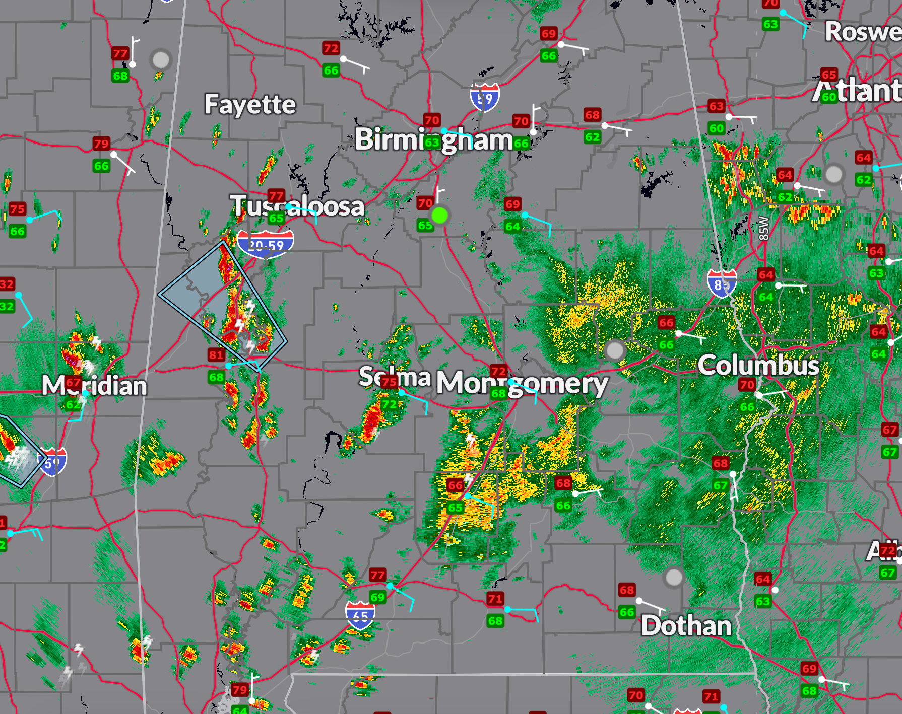
A strong thunderstorm continues to move northwest across parts of west-central Alabama this afternoon, prompting advisories for Greene, Hale, Sumter, and Marengo counties through 3:15 PM. At 2:29 PM, radar indicated a storm near Forkland, tracking toward Demopolis at 30 mph. Wind gusts up to 40 mph and half-inch hail are possible with this storm. Other developing storms are noted along and southwest of the I-65 corridor, including Butler County, with scattered activity building across Mobile, Baldwin, Monroe, Washington, Clarke, and Escambia counties. Elsewhere, light to moderate rain persists in east-central Alabama between Montgomery, Dothan, and Columbus, GA. Conditions remain quiet north of US-78, with light rain around the Birmingham metro.
The broad upper-level low over the ArkLaMiss remains stationary this afternoon, supporting widespread lift across the region. A surface warm front is taking shape across southwest Alabama into southern Georgia, while a dry slot wraps into western Alabama, allowing sunshine and temperatures to rise into the upper 70s and near 80°F. In contrast, areas farther northeast remain cloudy and cool due to a lingering but weakening wedge of easterly flow, with temperatures in the 60s. These contrasting air masses are fostering instability, especially across the west and southwest portions of the state.
Expect stronger storms to continue developing into the evening, particularly near the boundary draped across southwest Alabama. Effective bulk shear values of 40–45 knots and modest surface instability will support organized convection with a few strong to marginally severe storms possible. Hail and gusty winds remain the primary threats, though isolated flooding may begin to emerge where rainfall becomes persistent. A few marginally severe storms may linger into the evening and overnight, especially across western and central counties.
The greater concern overnight and into Monday morning continues to be flash flooding. Forecast models continue to advertise training thunderstorms capable of producing rainfall rates exceeding 2 inches per hour. These bands may gradually lift northward after midnight and become more scattered by sunrise. If persistent convection targets urban corridors or saturated areas, significant flooding may result. A *Flood Watch* remains in effect through 7 PM Monday. The closed low is finally expected to begin shifting east on Monday, though widespread showers and storms will redevelop, especially during the afternoon and evening. Another round of gusty winds, hail, and localized flooding will be possible.
Category: Alabama's Weather, ALL POSTS, Severe Weather, Social Media
About the Author (Author Profile)
Bill Murray is the President of The Weather Factory. He is the site's official weather historian and a weekend forecaster. He also anchors the site's severe weather coverage. Bill Murray is the proud holder of National Weather Association Digital Seal #0001 @wxhistorianSubscribe
If you enjoyed this article, subscribe to receive more just like it.


