Heavy Storms Flaring Along The Mississippi Border This Afternoon
Scattered strong thunderstorms continue to develop and intensify across west-central Alabama this afternoon, especially in counties bordering Mississippi. A strong storm currently impacting southwestern Sumter County near Kinterbish is moving northwest at 45 mph and may pose a hail threat. The National Weather Service has issued a Special Weather Statement for this storm, citing radar-indicated wind gusts up to 40 mph and penny-sized hail. Additional storms are forming in Hale and Perry counties, where destabilizing air and ample moisture are combining to support active convection.
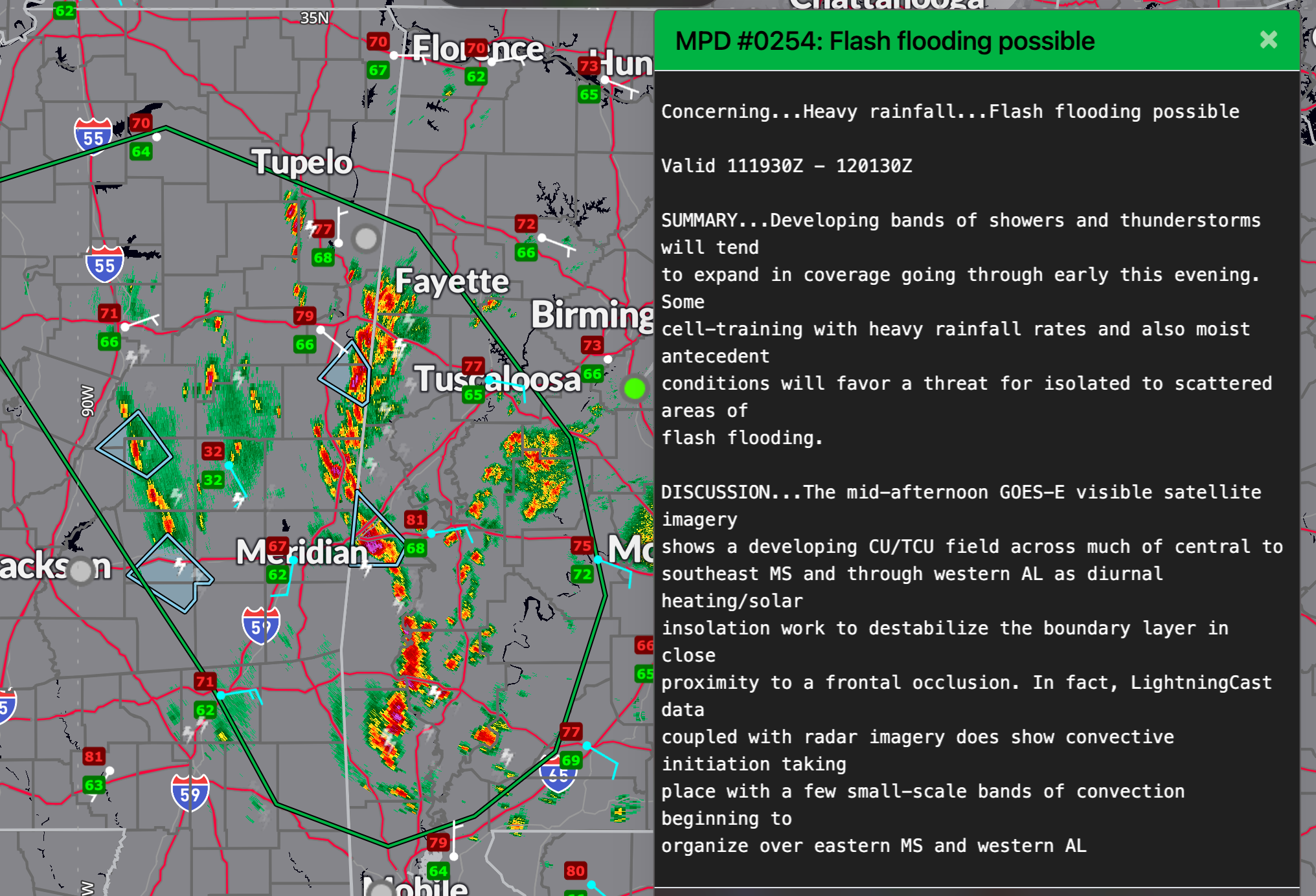
The environment across the region is becoming increasingly favorable for storms with heavy rainfall. According to the Weather Prediction Center’s latest Mesoscale Precipitation Discussion, bands of thunderstorms are expected to expand in coverage through the early evening hours. With modest instability (MLCAPE values between 1000–1500 J/kg) and unidirectional cyclonic flow aloft, the setup supports the potential for training storms producing rainfall rates of 1 to 2 inches per hour. Moist antecedent conditions will make areas particularly vulnerable to flash flooding.
Widespread showers and storms are also building across central Mississippi and pushing into Alabama, with the heaviest rainfall focused just west of I-59. The most intense activity remains across counties like Sumter, Greene, Hale, and Perry. Radar shows developing storms in bands, and models continue to suggest totals of 2 to 4 inches may fall in some areas by evening. Urban and flood-prone locations should stay alert as additional storms develop and track northeastward over the next few hours.
A Flood Watch remains in effect for much of central Alabama through Monday evening, and a Marginal Risk (Level 1 of 5) for severe thunderstorms covers most of the area through 1 AM. Storm hazards include damaging wind gusts up to 60 mph and hail up to quarter size. With the upper low still anchored over the ArkLaMiss and strong southerly moisture transport in place, more storms are expected to develop tonight and again on Monday. Stay weather aware, especially if you are in areas that have already seen significant rainfall.
Category: Alabama's Weather, ALL POSTS, Severe Weather, Social Media
About the Author (Author Profile)
Bill Murray is the President of The Weather Factory. He is the site's official weather historian and a weekend forecaster. He also anchors the site's severe weather coverage. Bill Murray is the proud holder of National Weather Association Digital Seal #0001 @wxhistorianSubscribe
If you enjoyed this article, subscribe to receive more just like it.


