More Strong to Severe Storms Today, Significant Severe Threat Possible Tuesday
The calendar still says spring, but this weekend’s weather in Alabama is already flirting with summer. Humidity is rising, afternoon temperatures are reaching the mid and upper 80s, and thunderstorms are finding just enough instability to rumble through. Today brings another round of scattered convection and a marginal severe risk, but much of the day will be dry and warm. It’s a pattern that will continue for a few more days—warm, a little unsettled, and increasingly humid—before a stronger system brings more widespread storms by midweek. In the meantime, folks are enjoying outdoor graduations, beach weekends, and a preview of what’s to come as we close out May.
SEVERE STORMS THIS MORNING
Oklahoma airmailed us a batch of storms overnight that didn’t weaken as advertised and they are making a lot of noise this morning across Central Alabama with tremendous lightning and thunder, large hail, torrential rain, and winds of 70-80 mph. No tornadoes fortunately, but be in a safe place as these storms move through as they can bring down tree limbs and whole trees.
ANOTHER ROUND OF STORMS POSSIBLE TODAY
Showers and storms from last night’s MCS are clearing the region early this morning, and while the atmosphere will be worked over in spots, it won’t take long for destabilization to begin again. The atmosphere remains moist and moderately unstable, with the surface boundary lingering just south of the state. Outflow boundaries left behind from earlier storms could help trigger new development this afternoon and evening. If storms can get going, they’ll have enough shear to organize briefly, with the potential for damaging winds and hail. That said, storm coverage is expected to be scattered, with a lot of dry time across the region between cells.
UNSETTLED BUT WARM THROUGH MONDAY
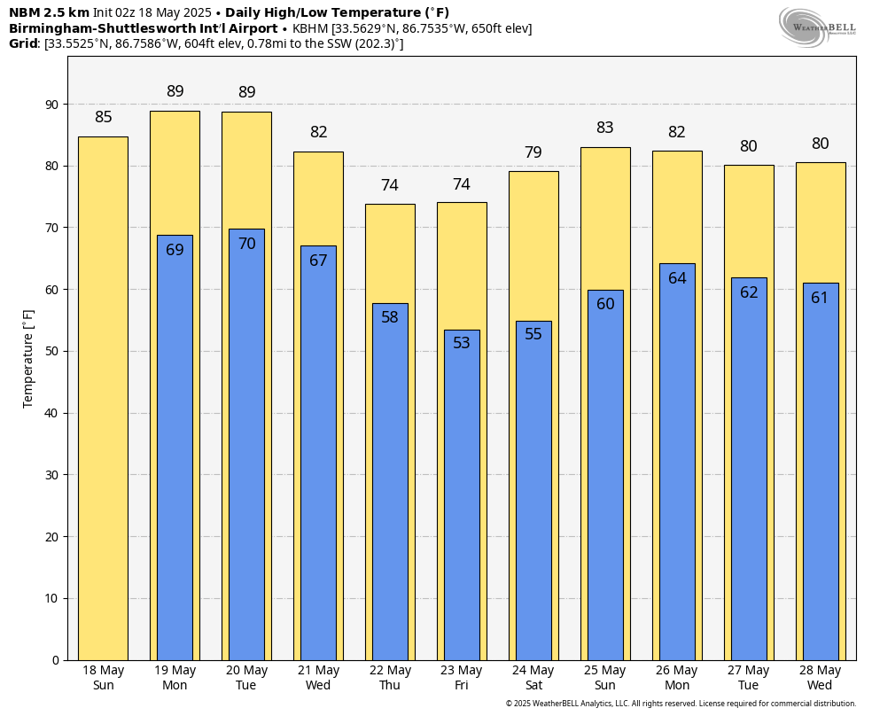
A series of weak disturbances riding in from the west will keep chances for showers and thunderstorms around through Monday, though severe weather is not expected. The pattern favors late-night and early-morning clusters of showers drifting in from the west or northwest, followed by warm and humid afternoons. Highs today and Monday will remain in the mid to upper 80s, with lows in the upper 60s to near 70. Coverage of storms may increase slightly Monday afternoon as the atmosphere moistens further.
TUESDAY COULD BE A SIGNIFICANT SEVERE WEATHER DAY
A powerful storm system will move into the region on Tuesday, bringing with it the potential for widespread severe weather across the Tennessee Valley and parts of the Deep South. The Storm Prediction Center already has a 15 percent severe weather probability extending as far south as the I-20 corridor, with a 30 percent risk zone covering northwest Alabama—including communities like Reform, Berry, Cordova, Hanceville, Guntersville, and Skyline. This level of concern at Day 4 is unusual and should not be taken lightly. Rich low-level moisture, steep mid-level lapse rates, and strong wind shear will combine with an uncapped atmosphere to support supercell development, particularly along and south of the Tennessee/Kentucky border. Large hail and damaging winds will be likely, and tornadoes—potentially numerous—are a distinct possibility. Storms may transition into a mesoscale convective system by evening, spreading a broader damaging wind threat as they move east. This has the makings of a high-impact day across our region.
A BRIEF COOL DOWN MIDWEEK
Behind Tuesday’s front, a refreshing change arrives for Wednesday and Thursday. Temperatures will drop back into the upper 70s and lower 80s, with noticeably lower humidity. Skies should be mostly sunny both days, and any lingering showers early Wednesday should clear quickly. Overnight lows will dip into the 50s for the first time in weeks in some spots, making for a pleasant mid-May break from the mugginess.
VOODOO TERRITORY: A RETURN TO UNSETTLED WEATHER
Looking into the extended period, long-range models suggest the ridge that builds in midweek will shift east by the weekend, opening the door to renewed storm chances. Moisture is expected to return from the Gulf, and with it, at least a chance for daily afternoon showers and thunderstorms by Saturday or Sunday. The week two outlook shows no clear signs of extreme heat or organized severe weather, but we’ll need to watch for subtle disturbances as the season edges toward June.
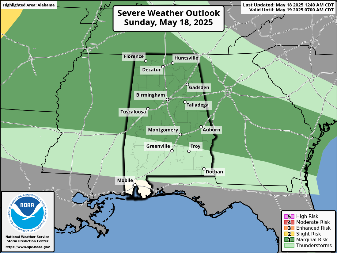
SEVERE WEATHER OUTLOOK
The Storm Prediction Center maintains a marginal risk of severe storms today across parts of Alabama and Georgia. Instability will be moderate, and shear will support some storm organization. While forcing remains weak along the front, a remnant MCS or MCV from Saturday’s activity could provide a focus for stronger development. If that plays out, localized damaging winds and hail are the primary risks Sunday afternoon.
TROPICAL WEATHER OUTLOOK
No tropical development is expected across the Atlantic basin over the next seven days. While we are still two weeks from the official start of hurricane season, early season systems occasionally develop in late May. At this time, however, global models show no organized disturbances forming in the western Caribbean or Gulf of Mexico. In the eastern Pacific, we may see the formation of Tropical Storm Alvin by late in the month according to the GFS model.
THE BEAUTIFUL BEACHES OF ALABAMA AND NORTHWEST FLORIDA
If you’re heading to the coast today, expect mostly sunny skies, highs in the mid 80s, and a southwest breeze around 10 mph. Water temperatures are around 80 degrees from Dauphin Island to Destin tp 30A to PCB. The rip current risk is low today and tomorrow, but as always, caution is urged near jetties and piers. Surf heights will remain 1 to 2 feet through Monday, with more favorable swimming conditions than we’ve seen in recent weeks. Look for an uptick in rip current risk by Tuesday as winds increase.
URGENT NOTICE: NOAA WEATHER RADIO OUTAGE PLANNED FOR NEXT WEEK
The National Weather Service office in Birmingham will temporarily take all of its NOAA Weather Radio transmitters offline from May 19 through approximately May 21 as part of a required software update to its AWIPS system. AWIPS—the Advanced Weather Interactive Processing System—is a critical tool for issuing forecasts, warnings, and integrating real-time weather and water data. While forecast and warning operations will continue without interruption in coordination with the NWS back-up office in Peachtree City, Georgia, NOAA Weather Radio broadcasts will be unavailable during the update. Affected transmitters include Winfield, Oneonta, Birmingham, Anniston, Tuscaloosa, Demopolis, Selma, Montgomery, Auburn, and Texasville. The Birmingham office will remain open and fully staffed during the outage, continuing to issue all products and respond to public and partner inquiries.
WEATHERBRAINS PREVIEW
We’ll be talking warnings Monday night on WeatherBrains with National Weather Service expert—and longtime friend of the podcast—Kevin Laws. He’s assembled a panel to tackle some big questions about the nation’s warning process, including the importance of skill scores like the false alarm rate and how those metrics affect real people. Join us live at 7:00 p.m. CDT on YouTube.com/WeatherBrains, or catch the episode anytime at WeatherBrains.com or wherever you get your podcasts.
THIS DAY IN WEATHER HISTORY
In 1980: A magnitude 5.1 earthquake struck beneath Mount St. Helens in southwest Washington State at 8:32 a.m., setting off one of the most catastrophic volcanic eruptions in U.S. history. The north flank of the volcano collapsed in the largest landslide ever recorded, triggering a violent lateral blast that leveled 230 square miles of forest. Pyroclastic flows and massive lahars tore through the valleys, forcing widespread evacuations. The eruption sent ash more than 80,000 feet into the atmosphere, with fallout reaching the East Coast in three days and circling the globe in 19. Fifty-seven people were killed, including renowned volcanologist David A. Johnston. The event reshaped the regional landscape and changed the course of volcano science and emergency management in the United States.
Category: Alabama's Weather, ALL POSTS, Severe Weather, Social Media
About the Author (Author Profile)
Bill Murray is the President of The Weather Factory. He is the site's official weather historian and a weekend forecaster. He also anchors the site's severe weather coverage. Bill Murray is the proud holder of National Weather Association Digital Seal #0001 @wxhistorianSubscribe
If you enjoyed this article, subscribe to receive more just like it.


