Sunday Morning Alabama Update at 6:45
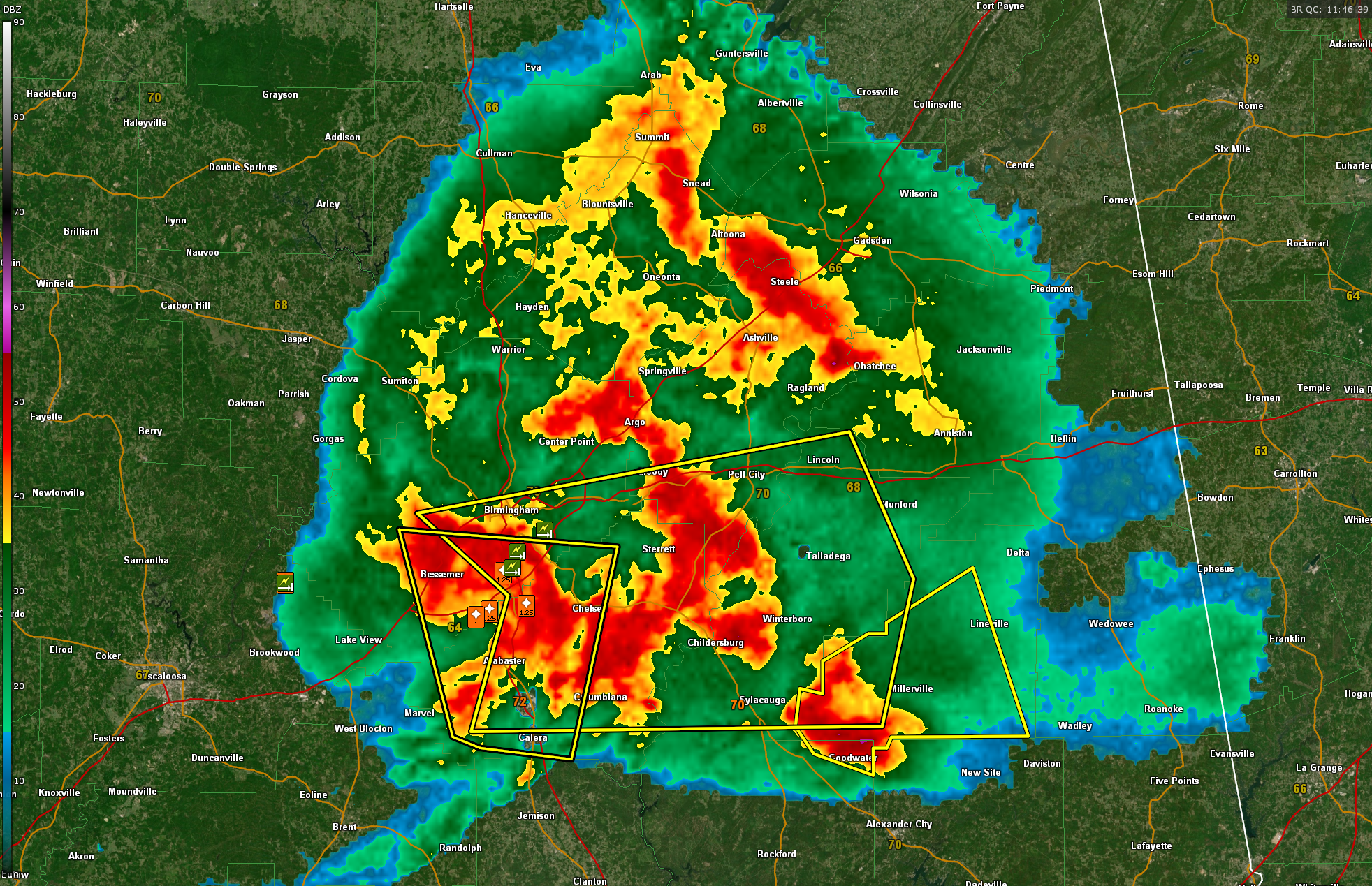
A long-lived thunderstorm complex has been pounding parts of Central Alabama this morning, producing large hail, damaging winds, and numerous Severe Thunderstorm Warnings. The storms have already triggered wind gusts estimated up to 80 mph and hail over one inch in diameter, with multiple reports of tree damage including downed trees on South Shades Crest Road in Jefferson County. A particularly intense storm earlier this morning prompted a destructive severe thunderstorm warning for parts of Shelby, Jefferson, Tuscaloosa, and Bibb counties.
As of 6:40 AM, the Storm Prediction Center issued a Mesoscale Discussion indicating that the thunderstorm complex moving across the region is organizing into a more dangerous system, showing signs of a developing mesoscale convective vortex (MCV) and a rear-inflow jet. This structure is often associated with more efficient damaging wind production and a longer-lived severe threat. While a new watch has not yet been issued, the SPC has increased the potential for watch issuance to 40 percent and is closely monitoring conditions across Central Alabama and west-central Georgia.
At 6:44 AM, a new Severe Thunderstorm Warning was issued for Talladega, Shelby, Clay, southeastern Jefferson, and southwestern St. Clair counties. This fast-moving line of storms is racing east at 60 mph and is capable of producing 70 mph wind gusts and quarter-size hail. Areas from Mountain Brook and Liberty Park to Lincoln, Westover, and Sylacauga are directly in the path of this latest surge of severe weather. Expect damage to trees, roofs, and vehicles, and be ready to move to shelter quickly.
While this round of storms will move out by mid to late morning, the question becomes whether the atmosphere will recover enough for another round of storms later today. At this time, additional development appears possible but limited, especially in southern counties where the environment may remain unstable. However, any redevelopment would likely be more isolated and less intense than this morning’s organized cluster.
Looking ahead, all eyes are on Tuesday, when a powerful storm system is expected to sweep into the region. With deep moisture, strong wind shear, and robust instability, there is a significant risk for widespread severe thunderstorms—including damaging winds, large hail, and tornadoes. The Storm Prediction Center has already highlighted much of northern and central Alabama with a Level 2 to Level 3 severe risk. Now is a good time to review severe weather safety plans and ensure warning systems are working.
Behind Tuesday’s front, expect a refreshing break with dry air, cooler temperatures, and sunny skies by midweek. Highs will fall back into the upper 70s and lower 80s Wednesday and Thursday, with lower humidity making it feel more like spring once again.
Category: Alabama's Weather, ALL POSTS, Severe Weather, Social Media
About the Author (Author Profile)
Bill Murray is the President of The Weather Factory. He is the site's official weather historian and a weekend forecaster. He also anchors the site's severe weather coverage. Bill Murray is the proud holder of National Weather Association Digital Seal #0001 @wxhistorianSubscribe
If you enjoyed this article, subscribe to receive more just like it.


