An Update on the Alabama Weather Situation at 4:40 p.m.
Alabama is preparing for a bout of severe weather tonight from an unusually strong May storm system that will bring all modes of severe weather to the northern and Central portions of Alabama, including damaging winds, large hail, and even tornadoes.
Tornadoes are unusual in mid to late May in Alabama but not unheard of. May 27, 1973 featured a significant outbreak of tornadoes including a long track F4 tornado that killed five in the town of Brent in Bibb County and a total of seven along its 139.1 mile path. That same tornado destroyed the WSR-57 radar at Centreville. Another person died in a tornado that struck Center Point.
One thing missing today is the strong surface low like we had on that Sunday in 1973. We had a strong surface low near Cape Girardeau MO that morning with a pressure of 982 mb.. Our low today is near Chicago, with a minimum pressure of 1008 mb.
Today will not be like May 27, 1973 most likely, but it does underscore that strong tornadoes can occur this time of year. On this date in 1883, there was a violent tornado in Henry County near the town of Headland.
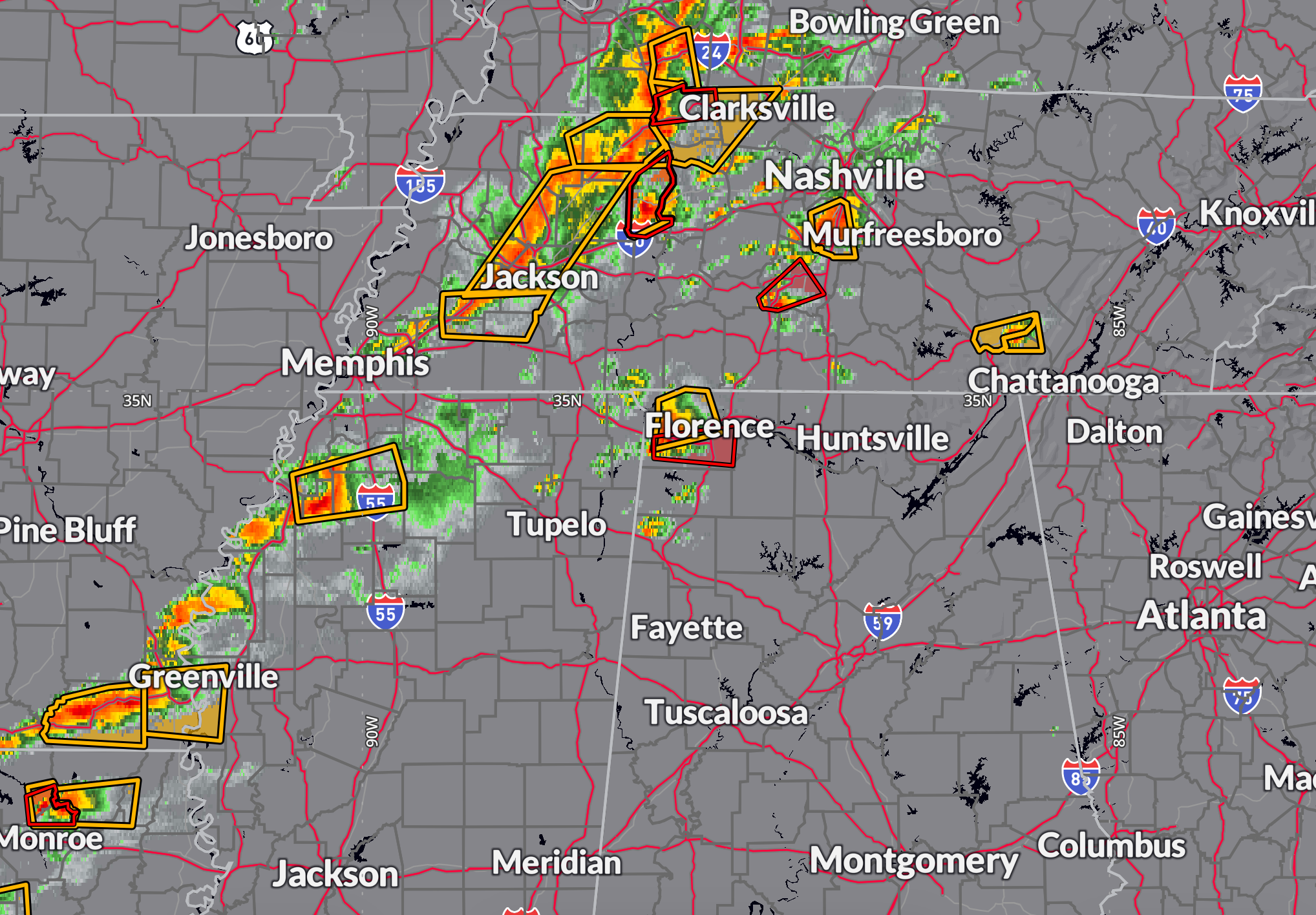
CURRENT SITUATION
There is a long squall line ahead of a cold front stretching from southern Kentucky to southwest Mississippi. There are a few cells out front of the storm with one warning in Kentucky, 2 in south-central Tennessee and one warning caused by a cell moving into Lauderdale county Alabama, and a couple warnings southwest of Greenville Mississippi. A Tornado watch currently spans throughout north-central Mississippi, northern Alabama, most of Tennessee and Southern Kentucky.
METEOROLOGICAL SETUP
A powerful spring weather system is driving today’s severe weather threat across Alabama. A deep trough is digging into the central U.S. and taking on a negative tilt, while a cold front advances eastward through the Lower Mississippi Valley. Ahead of this front, a very moist and unstable air mass is in place, with surface temperatures in the 80s and dewpoints near 70 degrees. Instability values (MLCAPE) are in the 2000–3000 J/kg range across much of Central and North Alabama. At the same time, deep-layer wind shear is increasing, with effective bulk shear of 50–60 knots already in place. A strengthening low-level jet will add further support for organized convection. These ingredients—rich moisture, strong instability, and increasing wind shear—will support the development of supercells and bowing line segments capable of producing damaging winds, large hail, and tornadoes… some of which could be strong.
IMPACTS
The impacts from this evening’s storms could be significant, especially across the northern half of Central Alabama. All severe weather hazards are on the table, including damaging straight-line winds up to 70 mph, large hail up to golf ball size, and tornadoes—some of which may be strong. The greatest tornado threat will be early in the event with any discrete supercells that form along and north of the I-20 corridor. As storms organize into a line and push southeastward, damaging winds will become the dominant threat, but embedded tornadoes will remain possible. Frequent cloud-to-ground lightning and torrential rainfall may also accompany the stronger storms, leading to isolated areas of flash flooding, especially in urban or previously saturated areas.
TIMING
Storms are expected to begin entering northwest Alabama by around 5 PM CDT, spreading southeast through the evening. The Birmingham metro area could be impacted between 7 PM and 10 PM, with areas farther southeast, including Montgomery and Auburn, seeing storms between 10 PM and 3 AM. The greatest severe threat—especially for tornadoes and large hail—will occur earlier in the evening with any discrete cells. As the storms organize into a line and push farther southeast overnight, the threat will transition to damaging winds and become more scattered in nature. Most of the activity should exit the state by around sunrise Wednesday.
SAFETY
With the threat of tornadoes, damaging winds, and large hail tonight, it’s crucial to have multiple reliable ways to receive warnings. Do not rely solely on outdoor sirens. Make sure your phone is charged and enabled to receive Wireless Emergency Alerts. A NOAA Weather Radio (for North Alabama only as the Central Alabama Weatheradio transmitters are ALL down), mobile weather apps, local broadcast media, or trusted social media accounts are all good tools. If a warning is issued for your location, seek shelter immediately in a small, interior room on the lowest floor of a sturdy building. Avoid windows, and have helmets, shoes, and a way to communicate if power is lost.
NWS AND WEATHER RADIO SITUATION
Because of a major system upgrade at the Birmingham forecast office, NOAA Weather Radio transmitters across Central Alabama are off the air tonight. Additionally, all warnings and forecasts for Central Alabama are being issued remotely by NWS Birmingham staff deployed to the National Weather Service office in Peachtree City, Georgia. Despite the outage, all warnings will still be delivered through other standard channels including TV, radio, websites, apps, and Wireless Emergency Alerts. Social media updates and local communication will continue to be managed from the Birmingham office.
We will be starting a live Blogcast by 5:30 pm right here on AlabamaWX.
Category: Alabama's Weather, ALL POSTS, Severe Weather, Social Media
About the Author (Author Profile)
Bill Murray is the President of The Weather Factory. He is the site's official weather historian and a weekend forecaster. He also anchors the site's severe weather coverage. Bill Murray is the proud holder of National Weather Association Digital Seal #0001 @wxhistorianSubscribe
If you enjoyed this article, subscribe to receive more just like it.


