Midday Nowcast: Fantastic Friday; Storms at Times through Memorial Day Weekend
FANTASTIC FRIDAY: Beautiful weather to end the work week across Alabama as we are seeing more sun than clouds and comfortable conditions. Low humidity and afternoon highs in the upper 70s and lower 80s, it is a pretty pleasant late May day.
BIRMINGHAM ALMANAC: For May 23rd, the average high for Birmingham is 84° and the average low is 63°. The record high is 95° set in 1996, while the record low is 47° set in 1954. We average 0.15” of precipitation on this date and the record value is 3.12” set in 2020.
MEMORIAL DAY WEEKEND: The forecast for tomorrow, Sunday, and Monday will feature sun at times, clouds at times, and rain and storms at times, especially for the northern two-thirds of Alabama.
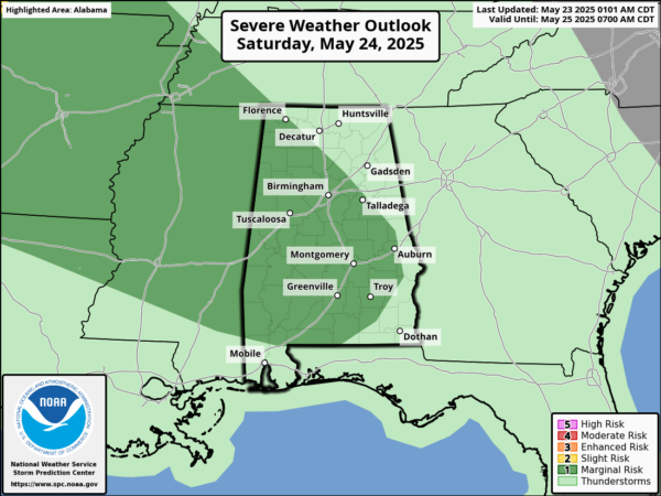
Both Saturday and Sunday, the Storm Prediction Center has a “marginal risk” (level 1 of 5) of severe storms for much of Alabama. Some storms could reach marginally severe limits during the peak heating of the day with gusty winds and hail the main threats.
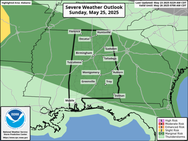
There is just isn’t much of a tornado threat, but I like to say this when I can, in the words of the Late, Great J.B. Elliott, “Always be prepared for the unexpected when it comes to Alabama storms.” Memorial Day itself, will feature the highest chances of rain as the storm activity becomes more widespread. Highs all three days this weekend will be in the low to mid 80s, while lows will be in the 60s. It will not be a weekend “wash out,” but just know showers and storms will be possible at time all this weekend.
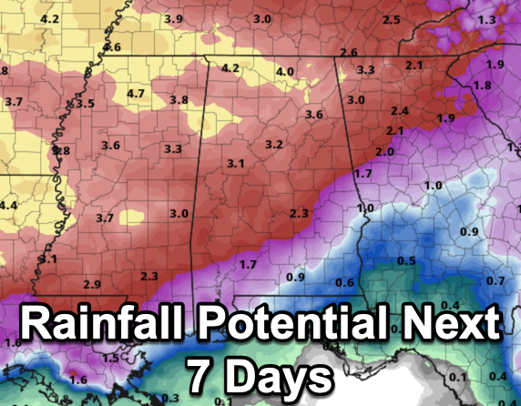
NEXT WEEK: For the final week of May, Tuesday and Wednesday will continue to feature the chance for likely showers and storms as a cold front approaches. Even for the latter half of the week, it looks like we are going to have to continue to maintain the chance for daily showers and storms. Highs should be in the 80s much of the week with very muggy conditions. Rainfall potential across Alabama will vary greatly with many location likely seeing 2-4 inches of beneficial rain. However, we know this time of year rainfall distribution is very uneven, and we call it feast of famine. Some locations will see a lot, while other, not much at or all, or even none.
BEACH BOUND: The weather looks great from Dauphin Island east through Gulf Shores, Orange Beach, Pensacola Beach, Destin, Fort Walton and Panama City through the weekend. It will be generally dry with highs at the beach will be in the 80s, with low 90s inland. Water temperatures as of this morning were ranging from the upper 70s to low 80s. Also, this is a reminder to PLEASE, pay attention to the Rip Current Flag Warning System at each beach. Rip currents are the #1 weather-related killer at the beaches along the northern Gulf Coast. There have been a staggering 213 rip current fatalities since 2002 in the beaches covered by the National Weather Service Offices in Tallahassee, FL and Mobile, AL. That is more than the fatalities of flooding, tornadoes, lightning, and tropical storms/hurricanes COMBINED!!
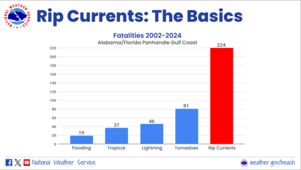
A powerful, narrow channel of water flowing away from the beach. Rip currents typically extend from near the shoreline out through the breaker zone where breaking waves form. Rip currents can and do occur on clear, sunny days. Think of a rip current like this – it is a natural treadmill traveling away from the beach. Rip currents can travel as fast as 8 feet per second – that’s faster than an Olympic swimmer! A rip current is dangerous because it can sweep even the strongest swimmers out to sea. For that reason, rip currents are life-threatening to anyone entering the surf. Rip currents also commonly form around breaks in sandbars and near inlets, jetties, and piers (where they are more intense).
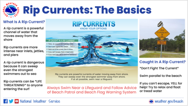
The rip current forecast is low to moderate range much of the weekend, but that can change day to day and from beach to beach. We also note, areas closer to the Panama City area, tend to have stronger rip current than the rest of the Northern Gulf Coast due to northwest to southeast topography of the coast.
WORLD TEMPERATURE EXTREMES: Over the last 24 hours, the highest observation outside the U.S. was 122.7F at Sibi Pakistan. The lowest observation was -111.3F at Vostok, Antarctica.
CONTIGUOUS TEMPERATURE EXTREMES: Over the last 24 hours, the highest observation was 111F at Tecopa, CA. The lowest observation was 19F at Mackay, ID.
Category: Alabama's Weather, ALL POSTS, Social Media
About the Author (Author Profile)
Macon, Georgia Television Chief Meteorologist, Birmingham native, and long time Contributor on AlabamaWX. Stormchaser. I did not choose Weather, it chose Me. College Football Fanatic. @Ryan_StinnetSubscribe
If you enjoyed this article, subscribe to receive more just like it.


