Alabama Weather Update at 6:05 p.m.: Monitoring More Storms to the Northwest, Other Storms Developing Over Northeast Alabama
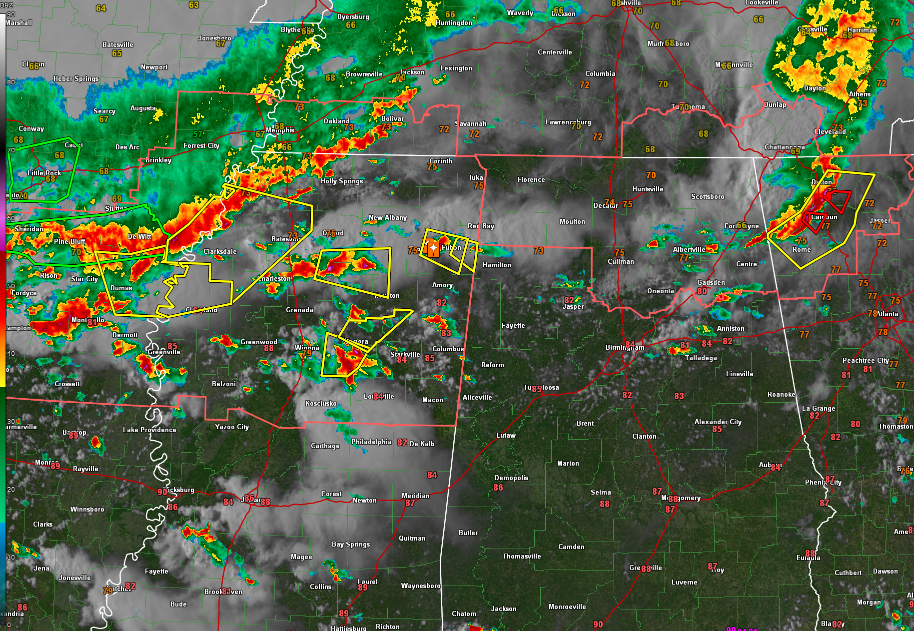
It’s a stormy evening across parts of Alabama as several rounds of thunderstorms continue to move across the region. The earlier complex of storms that swept across North Alabama has moved into northwest Georgia, but new activity has already fired along and ahead of lingering boundaries. As of 6 PM, scattered strong to severe storms were ongoing across portions of northeast Alabama—particularly in Etowah, Cherokee, St. Clair, Talladega, Shelby, and Marshall counties—some forming in the wake of the morning MCS and potentially tapping leftover boundaries and residual instability. These storms are capable of producing gusty winds, hail, and very heavy rainfall.
Meanwhile, a more organized thunderstorm complex is gathering momentum to the northwest, extending from western Tennessee and eastern Arkansas into northern Mississippi. This developing MCS has a history of producing severe thunderstorms, with numerous warnings active in northeast Mississippi as it approaches the Alabama state line. This same system is expected to dive southeastward through the evening and may reach northwest Alabama as early as 8–10 PM. The environment will be more stable than earlier in the day, especially in areas already affected by rain and storms, but some recovery may occur. If sufficient instability remains, a renewed round of strong storms with damaging winds could affect parts of northwest and west-central Alabama. However, it’s also possible the system could weaken or slide just south, depending on how competing boundaries interact.
A Severe Thunderstorm Watch remains in effect until 11 PM for the Tennessee Valley counties of North Alabama. Although the immediate severe threat in northeast Alabama has decreased since the earlier MCS exited, new development in its wake remains worth monitoring. Storms currently bubbling from eastern Cullman County across Marshall into DeKalb County may briefly pulse to severe levels before gradually weakening. These will drift generally east to southeast with time, posing a risk of gusty winds and heavy rain.
Flash flooding is also a growing concern. A Mesoscale Precipitation Discussion issued by the Weather Prediction Center highlights the potential for 2 to 4 inches of rain, with localized totals approaching 5 inches. The atmosphere remains primed for heavy rainfall with precipitable water values near or above 2 inches and storm motions that could favor training segments. Patchy fog may develop overnight, especially in areas that have seen heavy rain and light winds, with lows ranging from the mid 50s in the north to near 70 in the south.
Looking ahead to Memorial Day, yet another round of storms is expected—this time arriving by late morning into early afternoon. Another MCS is forecast to develop and sweep southeast across the Mid-South, placing much of Alabama under a marginal risk (level 1 of 5) for severe storms. Damaging winds and hail will be the primary concerns once again. Expect highs from the lower 80s north to near 90 degrees in the far south, with showers and storms most likely from midday onward.
Category: Alabama's Weather, ALL POSTS, Severe Weather, Social Media
About the Author (Author Profile)
Bill Murray is the President of The Weather Factory. He is the site's official weather historian and a weekend forecaster. He also anchors the site's severe weather coverage. Bill Murray is the proud holder of National Weather Association Digital Seal #0001 @wxhistorianSubscribe
If you enjoyed this article, subscribe to receive more just like it.


