A 7:30 Weather Update for Southwest and Central Alabama
Active Storms Continue Over Southwest Alabama…More Expected Tonight
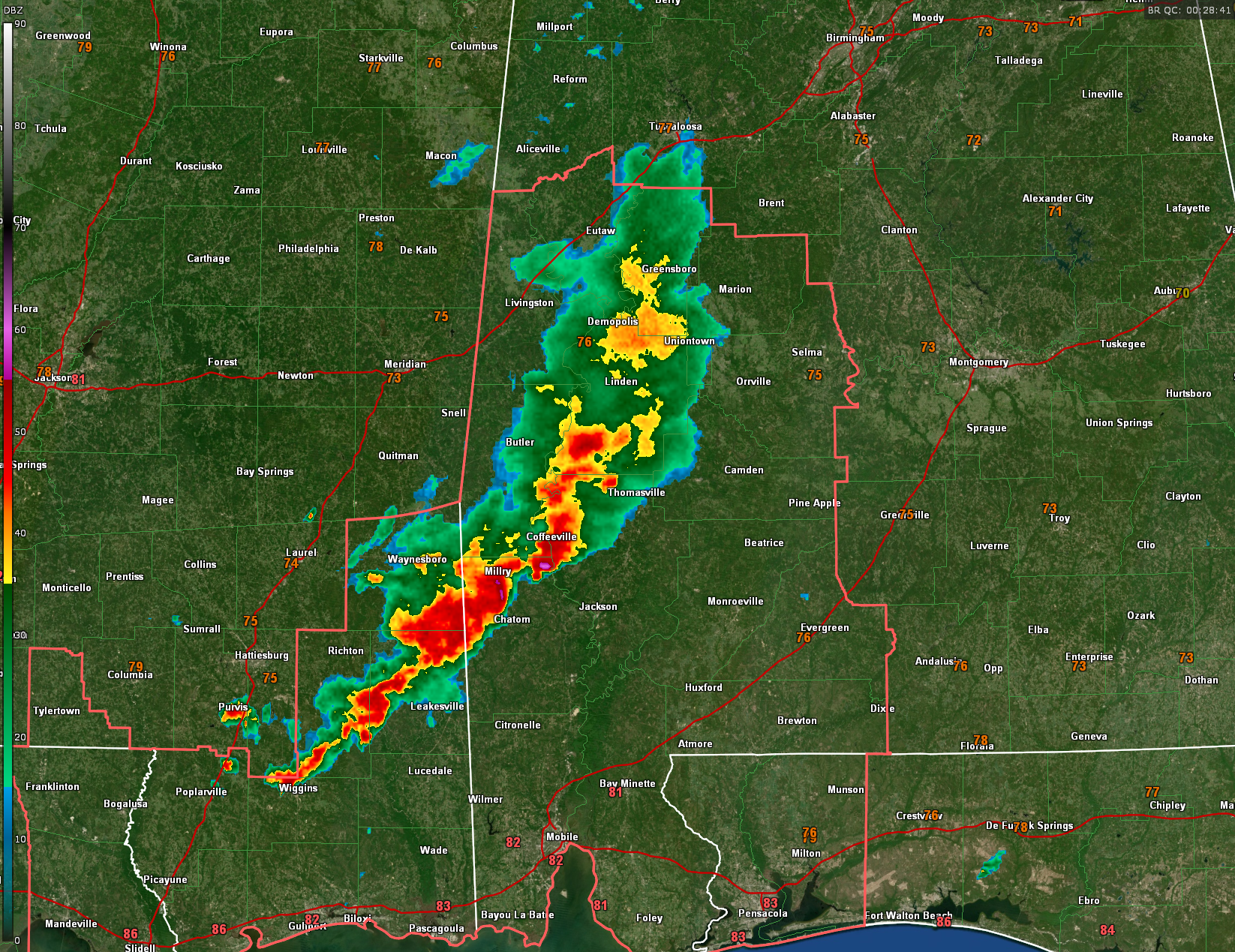
Strong thunderstorms are ongoing early this evening across southwest Alabama, particularly in a corridor from Choctaw and Marengo counties southeast through northern Clarke and Washington counties. The strongest storm at this hour is located near Frankville in northern Washington County, where radar indicates the potential for damaging wind gusts and perhaps some hail. These storms are associated with a slow-moving cluster tied to a remnant MCV, drifting eastward through the central Gulf Coast region. No warnings are in effect as this time, just significant weather advisories
for the stronger storms.
The Storm Prediction Center has issued a mesoscale discussion for this area, noting a 60% chance of a new Severe Thunderstorm Watch as the cluster organizes further. Moderate instability and favorable low-level moisture may allow these storms to intensify slightly as they drift east-southeast, with damaging wind gusts the primary concern, though some hail remains possible with the more discrete cells. Radar shows this system gradually evolving from isolated cells into a more organized cluster, potentially bringing broader wind impacts with time.
Across central Alabama, earlier storms have now pushed into Georgia, ending the immediate severe threat for much of the area. However, another upper-level disturbance is expected to spark new storm development between 7 PM and 10 PM, especially west of I-65. With saturated ground and recent flood reports, any additional heavy rain tonight could quickly lead to flash flooding, especially in flood-prone urban and rural areas. A Flood Watch remains in effect for parts of central Alabama through at least 1 AM.
Overnight, clearing skies could lead to dense fog development, particularly in northern counties near the Tennessee border. If clouds dissipate more quickly than expected, light winds and wet ground could set the stage for visibility reductions by early Wednesday morning. Conditions will dry out a bit tomorrow, but the broader active pattern continues through the week with high rain chances each day.
Category: Alabama's Weather, ALL POSTS, Severe Weather, Social Media
About the Author (Author Profile)
Bill Murray is the President of The Weather Factory. He is the site's official weather historian and a weekend forecaster. He also anchors the site's severe weather coverage. Bill Murray is the proud holder of National Weather Association Digital Seal #0001 @wxhistorianSubscribe
If you enjoyed this article, subscribe to receive more just like it.


