Severe Thunderstorm Warning for Southeastern Chilton, Northwestern Elmore, and Southern Coosa Counties Until 12:30 PM CDT
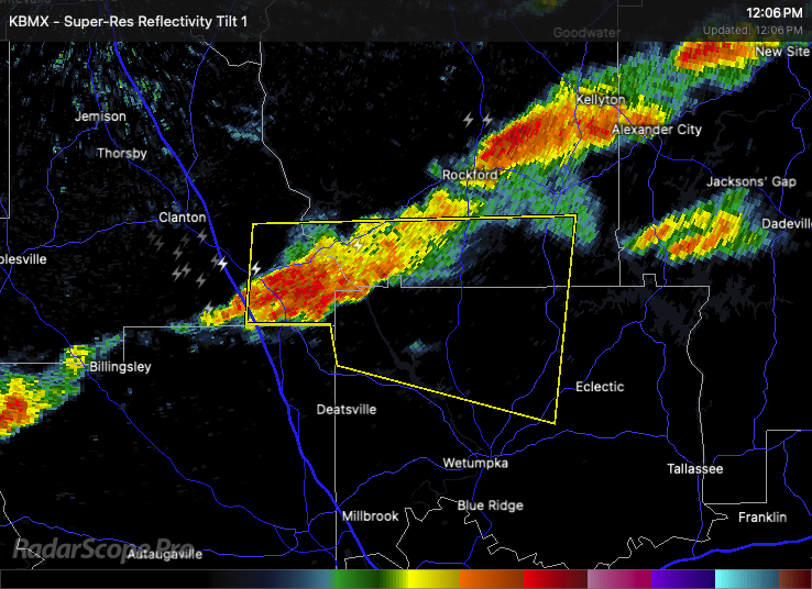
At 12:03 PM, a severe thunderstorm was located near Verbena, about 11 miles southeast of Clanton, moving east at 40 mph. This storm is capable of producing wind gusts up to 60 mph and penny-size hail.
Areas in the path of this storm include Equality, Speed, Pentonville, Santuck, Titus, Weoka Mills, Jordan Lake, Welona, Ten Cedar Estates, Nixburg, Dexter, Verbena, Mitchell Lake, Central, and Mitchell Dam.
Expect damage to roofs, siding, and trees. This is a potentially damaging storm—seek shelter now in an interior room on the lowest floor of a sturdy building. Stay away from windows until the storm passes.
Category: Alabama's Weather, ALL POSTS, Severe Weather, Social Media
About the Author (Author Profile)
Scott Martin is an operational meteorologist, professional graphic artist, musician, husband, and father. Not only is Scott a member of the National Weather Association, but he is also the Central Alabama Chapter of the NWA president. Scott is also the co-founder of Racecast Weather, which provides forecasts for many racing series across the USA. He also supplies forecasts for the BassMaster Elite Series events including the BassMaster Classic.Subscribe
If you enjoyed this article, subscribe to receive more just like it.


