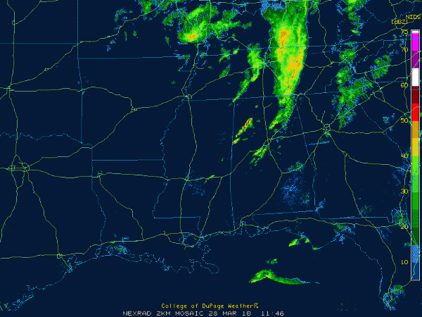
More Showers and Storms Developing
Showers and thunderstorms are developing across Central Alabama this morning.
Heavy showers and some storms developed in the last 45 minutes near Columbus MS and moved quickly into northern Pickens, Lamar, Fayette and southeastern Marion and Winston Counties in West Alabama.
A decent storm was located between Brilliant, Haleyville and Natural Bridge. These storms are not far from being hail producers.
Storms were trying to get organized between Clarence and Hayden in Blount County.
In Bibb County, other storms were between Coaling, West Blocton and Centreville, moving up in Shelby County.
Everything moving northeast at about 45 mph.
A narrow tongue of deeper moisture was moving up into West Alabama and providing fuel for these storms. The dewpoint at Columbus MS rose to 55F then fell back to 50F on the last observation. At Tuscaloosa, t he dewpoint is 54F. Birmingham has 51F.
The fuel is made a little higher octane by colder temperatures aloft that are moving in from the west.
There is sufficient shear to allow the storms to be organized.
So, until we get the cold front through here later today, there is still a chance of strong to severe storms. The best chance will be later this morning and early this afternoon between I-20 and I-85 and east of I-65, where there still could be a tornado threat as well with any organized storms that start rotating.
Hail will be a threat with the stronger storms.
We will be keeping a close eye on these storms through the morning hours.
Category: Pre-November 2010 Posts


