Midday Nowcast: Strong and Severe Storms Return to Alabama Friday and Saturday
ONLY ISOLATED STORMS TODAY: Today is a rather routine summer day across Alabama with a mix of sun and clouds and highs in the upper 80s and lower 90s. Some pop-up afternoon and evening showers and storms are possible, but these will be few and far between if and where they develop.
BIRMINGHAM ALMANAC: For June 5th, the average high for Birmingham is 86° and the average low is 66°. The record high is 100° set in 1985, while the record low is 47° set in 1946. We average 0.15” of precipitation on this date and the record value is 3.57” set in 2013.
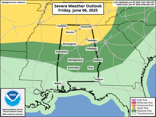
STORMS FRIDAY: The chance for rain and storms increases tomorrow as a front approaches from the north. The front, interacting with the tropical air mass in place brings those increasing rain and storm chances. Some strong storms are possible and the Storm Prediction Center maintains the northern third of Alabama in a level 2 threat of severe storms, while areas from Birmingham to Troy are in level 1 threat. Strong storms which develop could produce strong, gusty winds and hail. The tornado threat is very low, but NOT zero. Always be mindful of a surprise when it comes to thunderstorms in Alabama.
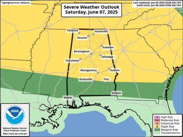
STORMY WEEKEND WEATHER: The Storm Prediction Center has nearly all of Alabama in threat of severe storms on Saturday, with the northern three-quarters of the state in a level 2 threat. The proximity of the front and the moisture-rich air mass in place will allow for widespread rain and storms at times Saturday, especially during the afternoon and evening hours. Stronger storms will produce strong, gusty winds and hail, and the tornado threat will be very low, but again, NOT zero. Additionally all storms will produce tropical downpours and frequent lightning. We will maintain the chance of scattered showers and thunderstorms on Sunday and for now the SPC has no part of Alabama included in a risk of severe storms Sunday, but know the radar will certainly be busy on Sunday too. Now the weekend won’t be a wash-out, and the sun will be out at times. It will remain warm and very muggy with highs in the 80s.
NEXT WEEK: The weather pattern remains more active than normal for June in Alabama. Expect high in the 80s each day, very muggy conditions, and daily scattered to numerous afternoon and evening showers and storms. Greatest coverage during the peak heating of the day, 2PM-10PM. Rain chances will be in the 40-60% most days next week.
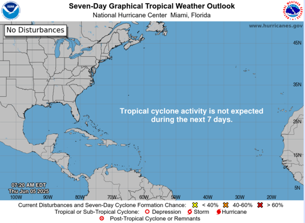
IN THE TROPICS: All is quiet and no tropical cyclone development is expected in the Gulf of Mexico, Caribbean Sea, or the rest of the Atlantic the next seven days.
WORLD TEMPERATURE EXTREMES: Over the last 24 hours, the highest observation outside the U.S. was 115.7F at Zabol, Iran. The lowest observation was -95.8F at Vostok, Antarctica.
CONTIGUOUS TEMPERATURE EXTREMES: Over the last 24 hours, the highest observation was 107F at Saratoga Springs and Death Valley, CA. The lowest observation was 21F at Mackay, ID.
Category: Alabama's Weather, ALL POSTS, Social Media
About the Author (Author Profile)
Macon, Georgia Television Chief Meteorologist, Birmingham native, and long time Contributor on AlabamaWX. Stormchaser. I did not choose Weather, it chose Me. College Football Fanatic. @Ryan_StinnetSubscribe
If you enjoyed this article, subscribe to receive more just like it.


