Strong to Severe Storms Possible Through Monday
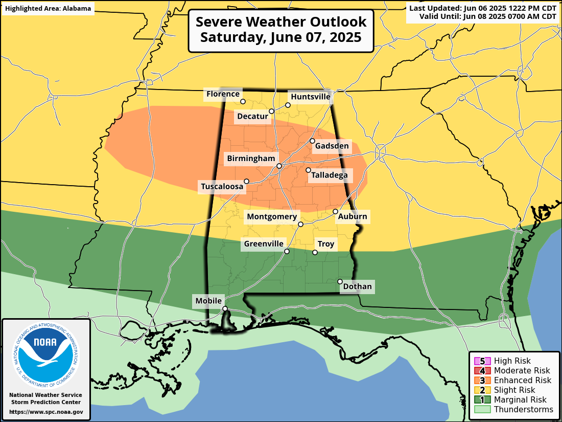
Today will bring the most significant weather of the forecast period. A line of severe storms is expected to develop in the afternoon and move through the area into the evening. The main threat will be damaging wind gusts between 60 and 70 mph, and there is also a chance for a few isolated storms ahead of the main line to produce large hail. The most intense weather is likely to occur between noon and 4 PM along and north of the I-20 corridor, then progress southeast through the evening, reaching areas near and south of I-85 by around 9 PM. Although the storms should weaken by around 10 PM, a few strong storms may still be ongoing late in the evening. An enhanced risk for severe storms includes locations south of a line from Littleville to Moulton to Collinsville, and north of a line from Eutaw to Billingsley to just north of Opelika. A slight risk is in place for the remainder of North Alabama north of the enhanced risk, and also for areas south of the enhanced risk, extending as far south as just south of Butler to right between Fort Deposit and Greenville to a few miles south of Eufaula. The rest of South Alabama is in a marginal risk. Highs will range from the mid-80s to mid-90s.
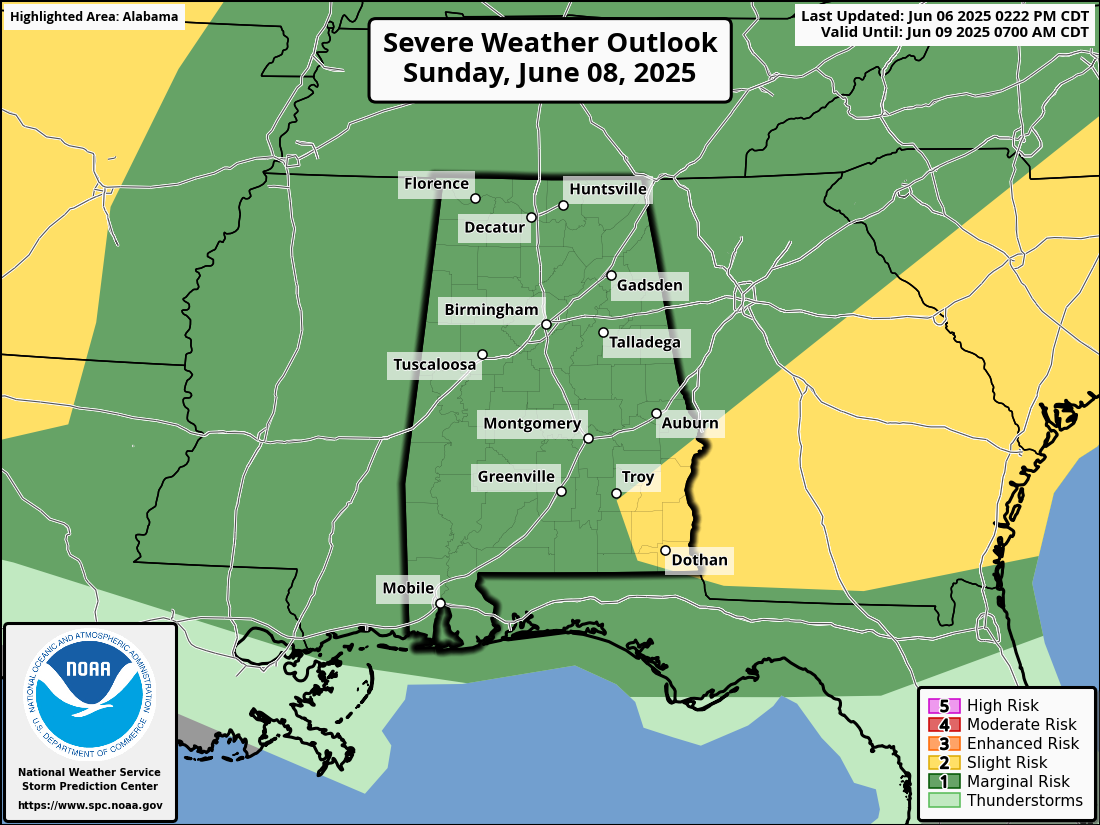
On Sunday, another round of storms is possible as additional storm clusters move into the region from the northwest. There is a low to moderate risk (Level 1 to 2 out of 5) for strong to severe storms, with damaging straight-line winds being the primary concern. Some areas may experience heavy rainfall, which could result in localized flooding. A marginal risk for severe storms is up for nearly the entire state, except for portions of the southeast corner, where a slight risk is up. That includes locations a few miles south of Phenix City to just north of Brundidge, down to Hartford, and down to the Alabama/Florida state line just south of Cottonwood. Storms are expected to taper off overnight as drier air begins to move in. Highs will range from the lower 80s to lower 90s.
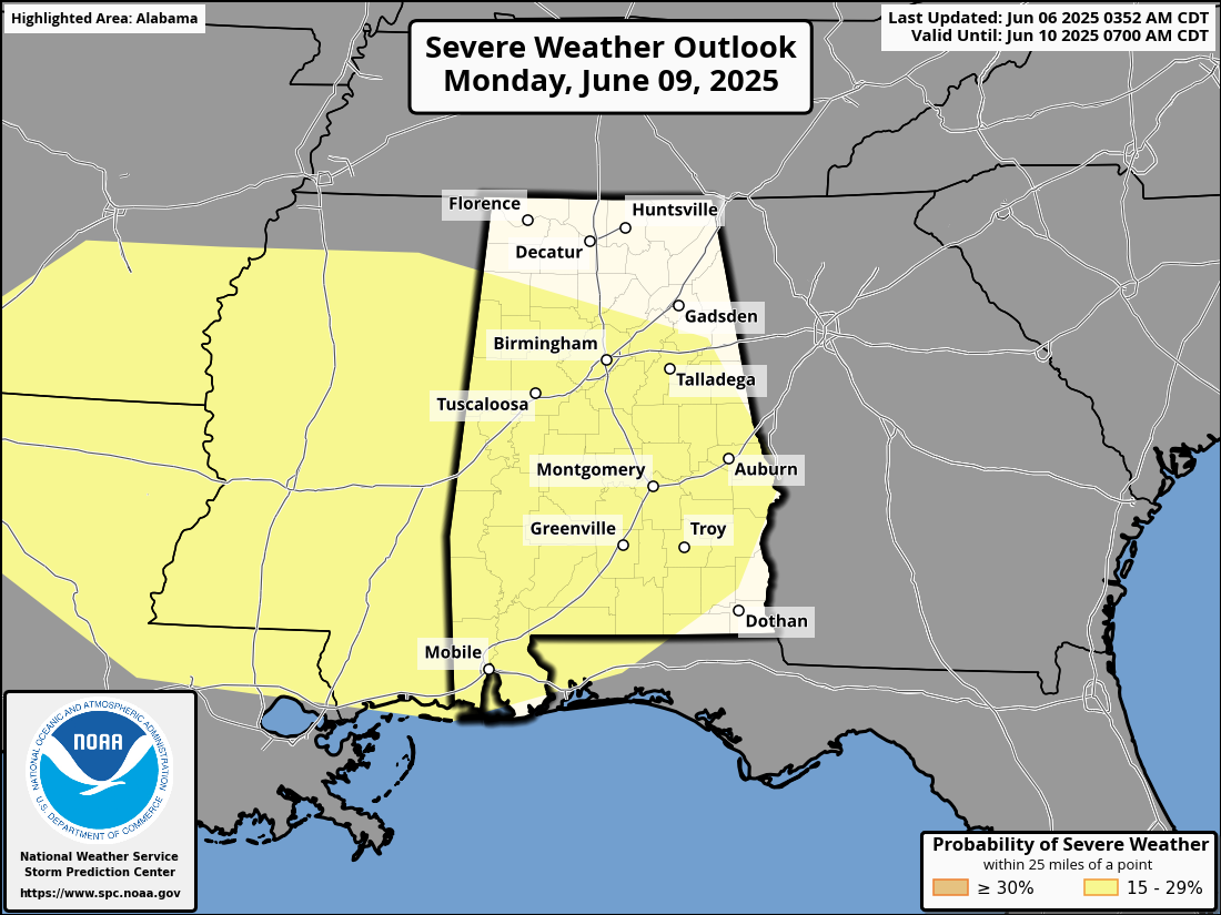
Monday continues the active weather pattern. The stalled front across Central Alabama will allow for more afternoon and evening storms to develop. While the severe threat is lower compared to Saturday and Sunday, a few strong storms cannot be ruled out. A 15% slight risk is up on the Day 4 Severe Weather Outlook for locations south of Shottsville to Damascus to Pleasant Ridge to Roanoke, except the extreme southeast corner of the state. Rain could linger overnight depending on the timing of upper-level disturbances. Highs will range from the lower 80s to lower 90s.
Tuesday will bring slightly cooler conditions as the frontal boundary slowly sags southeast and exits the area. Scattered thunderstorms are likely during the afternoon and evening. Although severe weather appears unlikely, localized flooding could still be a concern due to multiple rounds of rainfall in previous days. Highs will be in the 80s.
Wednesday will feature similar conditions with a continued chance for scattered showers and thunderstorms throughout the day. The overall risk for severe weather remains low, but occasional heavy rain and lightning may occur with any stronger storms. Highs will be in the 80s.
On Thursday, a summer-like pattern will return with warm and humid conditions along with scattered afternoon thunderstorms. These storms are expected to be more typical of early summer, with brief downpours and gusty winds possible. Highs will range from the mid-80s to lower 90s.
Friday will follow a similar trend, with isolated to scattered thunderstorms developing during the afternoon. No significant severe weather is expected, but the pattern of daily storms will likely persist. Highs will range from the upper 80s to lower 90s.
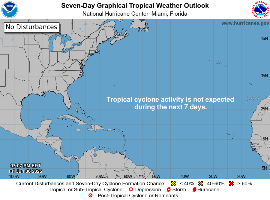
For the North Atlantic, Caribbean Sea, and the Gulf of Mexico: Tropical cyclone formation is not expected during the next 7 days.
Category: Alabama's Weather, ALL POSTS, Severe Weather, Social Media, Weather Xtreme Videos
About the Author (Author Profile)
Scott Martin is an operational meteorologist, professional graphic artist, musician, husband, and father. Not only is Scott a member of the National Weather Association, but he is also the Central Alabama Chapter of the NWA president. Scott is also the co-founder of Racecast Weather, which provides forecasts for many racing series across the USA. He also supplies forecasts for the BassMaster Elite Series events including the BassMaster Classic.Subscribe
If you enjoyed this article, subscribe to receive more just like it.


