Severe Thunderstorm Warning for Marion, Fayette, and Lamar Counties Until 1:30 PM CDT
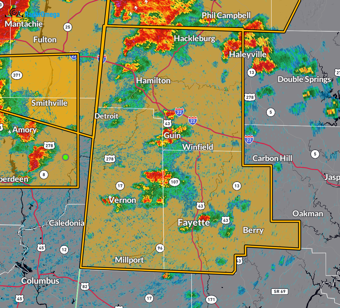
At 12:20 PM CDT, the National Weather Service in Birmingham issued a Severe Thunderstorm Warning for northwestern and west central Alabama, including Marion, Fayette, and Lamar counties. A line of severe thunderstorms was located stretching from near Thrashers to Tombigbee State Park to Pyland, moving east at 50 mph.
These storms are capable of producing extremely dangerous wind gusts up to 70 mph and quarter-size hail. Radar has indicated the presence of these threats. Expect hail damage to vehicles, widespread tree damage, and wind damage to mobile homes, roofs, and outbuildings.
Locations in the path of these storms include Hamilton, Winfield, Fayette, Vernon, Sulligent, Millport, Guin, Hackleburg, Berry, Brilliant, Glen Allen, Kennedy, Detroit, Belk, Beaverton, Gu-Win, Bluff, Boley Springs, Blooming Grove, and Brinn.
This is a dangerous situation. These storms have already caused widespread wind damage across eastern Mississippi. Take shelter immediately in a sturdy building, away from windows.
Large hail, damaging winds, and continuous cloud-to-ground lightning are occurring. If you can hear thunder, you are close enough to be struck by lightning. Move indoors right away. This warning remains in effect until 1:30 PM CDT.
Category: Alabama's Weather, ALL POSTS, Severe Weather, Social Media
About the Author (Author Profile)
Scott Martin is an operational meteorologist, professional graphic artist, musician, husband, and father. Not only is Scott a member of the National Weather Association, but he is also the Central Alabama Chapter of the NWA president. Scott is also the co-founder of Racecast Weather, which provides forecasts for many racing series across the USA. He also supplies forecasts for the BassMaster Elite Series events including the BassMaster Classic.Subscribe
If you enjoyed this article, subscribe to receive more just like it.


