An Update on the Alabama Severe Weather Situation Through the Overnight Hours into Sunday Morning
The severe weather setup tonight across Alabama is being driven by an evolving mesoscale environment to our west. A moisture-rich air mass remains in place across northern Mississippi and western Alabama, with CAPE values ranging from 2000 to 3000 J/kg in the more unstable zones just west of the state line. Storms have erupted along a theta-e gradient from central Arkansas into northern Mississippi—some with supercell characteristics—and are feeding off this buoyant air mass. While a modest cap was in place earlier today, cooling temperatures aloft and subtle height falls associated with a mid-level disturbance have helped erode that inhibition. This could support the growth of a forward-propagating MCS that moves into western Alabama during the late-night hours.
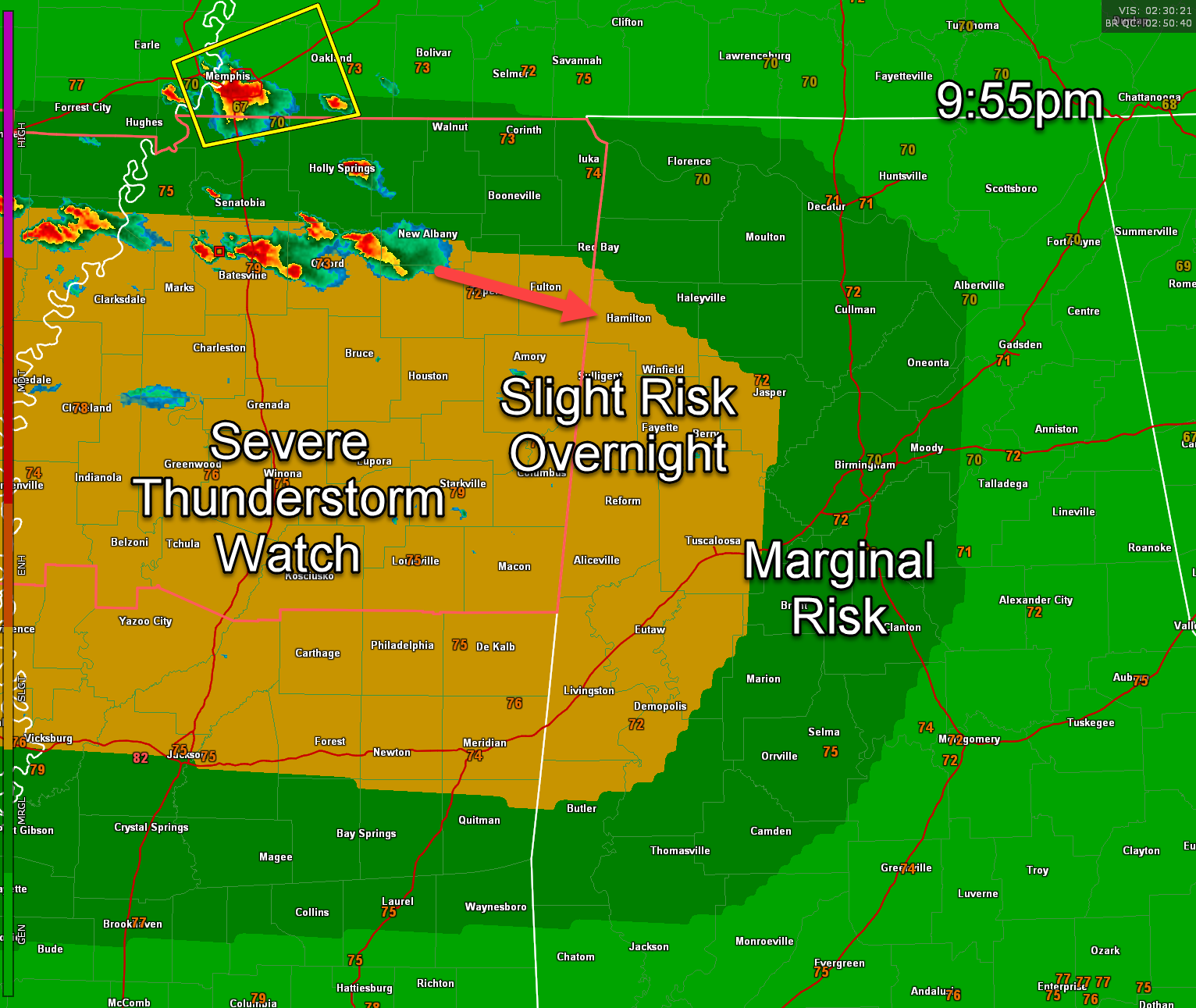
A severe thunderstorm watch is in effect for the northern half of Mississippi until 2 a.m.
Right now, there is a dangerous storm passing north of Oxford, MS that has had a tornado warning on it. It has showed signs of strong rotation but no tornado debris signature. On its present track, this storm will reach West Central Alabama in the vicinity of Marion and Lamar Counties about 1145 pm. We will be watching any activity over Northwest and West-Central Alabama in the period after midnight as shear profiles indicate some chance of a tornado.
Though earlier convection across Alabama did work over the atmosphere, models suggest that west Alabama may recover enough to support at least isolated severe storms. Soundings and radar signatures from upstream suggest shear profiles supportive of modest low-level rotation, especially in areas where boundaries enhance storm interactions. As these storms push into western Alabama—particularly areas southwest of Tuscaloosa and into the Black Belt—the potential exists for damaging winds and hail, with a non-zero tornado risk where storm-scale processes allow for deviant motion. The SPC is currently monitoring the situation closely with Severe Thunderstorm Watch 389 in effect to the west and has hinted at possible eastward expansion if trends continue.
By 10 am or so Sunday morning, this round of storms should exit the area, leaving behind an outflow boundary that will likely stall between I-20 and I-85. This will set the stage for potential redevelopment by midday or afternoon ahead of the weak cold front, although the threat level will depend on how much instability can rebuild behind the early morning activity. There could be storms, though, in the I-20/59 corridor around noon through 6 pm and those could well be strong to severe.
For now, the highest severe threat into the overnight hours appears focused on western and southwestern Alabama, with strong winds and hail being the main concerns. Stay weather-aware overnight, especially in counties west of I-65.
Category: Alabama's Weather, ALL POSTS, Severe Weather, Social Media
About the Author (Author Profile)
Bill Murray is the President of The Weather Factory. He is the site's official weather historian and a weekend forecaster. He also anchors the site's severe weather coverage. Bill Murray is the proud holder of National Weather Association Digital Seal #0001 @wxhistorianSubscribe
If you enjoyed this article, subscribe to receive more just like it.


