New Mesoscale Discussion
Storms continue late tonight from southern Arkansas into northern Mississippi, where rich moisture, strong instability (MLCAPE over 2000 J/kg), and effective shear support the potential for isolated supercells. While weak midlevel lapse rates have limited storm intensity so far, occasional severe storms with hail, damaging winds, or a tornado remain possible. Some storms could approach western Alabama, but it’s unclear whether a new watch will be issued there due to a less favorable environment.
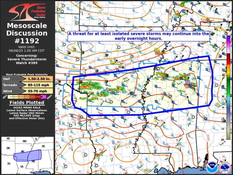
Mesoscale Discussion 1192
NWS Storm Prediction Center Norman OK
1129 PM CDT Sat Jun 07 2025
Areas affected…ArkLaTex into parts of northern MS/AL
Concerning…Severe Thunderstorm Watch 389…
Valid 080429Z – 080600Z
The severe weather threat for Severe Thunderstorm Watch 389
continues.
SUMMARY…A threat for at least isolated severe storms may continue
into the early overnight hours.
DISCUSSION…Widely scattered strong to potentially severe storms
are ongoing in a corridor from southern AR into northern MS. The
environment remains favorable for supercells, with rich low-level
moisture, MLCAPE of greater than 2000 J/kg, and 40+ kt of effective
shear. However, midlevel lapse rates are rather weak with warm
temperatures aloft, and most storms thus far have struggled to
maintain severe intensity. Some increase in storm coverage remains
possible with time within a modest low-level warm-advection regime,
including the potential for occasional supercells with a threat of
hail, locally damaging wind, and possibly a tornado.
With time, some severe threat may spread out of WW 389 to the east
and south. Some local expansion of WW 389 may eventually be needed
(where possible), but additional watch issuance into a less unstable
environment across AL is uncertain, and will depend on short-term
observational trends as storms approach the edge of the watch.
..Dean/Gleason.. 06/08/2025
Category: Alabama's Weather, ALL POSTS, Severe Weather, Social Media
About the Author (Author Profile)
Bill Murray is the President of The Weather Factory. He is the site's official weather historian and a weekend forecaster. He also anchors the site's severe weather coverage. Bill Murray is the proud holder of National Weather Association Digital Seal #0001 @wxhistorianSubscribe
If you enjoyed this article, subscribe to receive more just like it.


