Midday Nowcast: Only Isolated Showers and Storms Today; Rain Chances Increase to End of Week
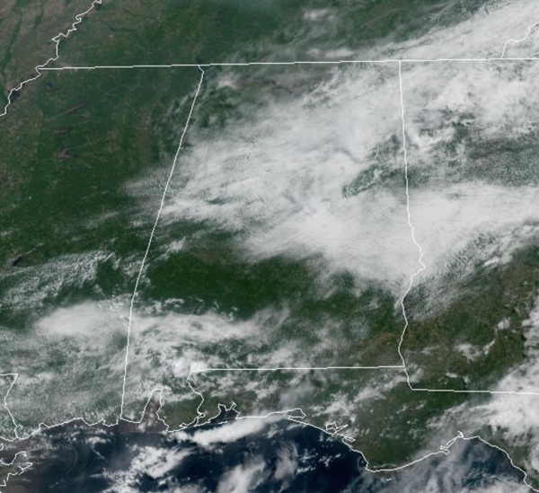
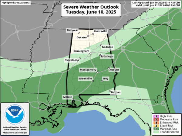
LOWER RAIN CHANCES: We are seeing a partly sunny sky today with only isolated showers and storms on the radar across Alabama. For the rest of today, these will remain widely spaced, but we note, portions of Alabama are including in “marginal risk” (level 1 of 5) of severe storms this afternoon.
Stronger storms could produce strong, gusty winds and of course frequent lightning and heavy rainfall. If you find yourself under one of these storms, you could see isolated flash flooding, however, most of Alabama will be relatively dry today with highs in the mid 80s.
Little change in the forecast for tomorrow; expect a partly sunny sky with isolated afternoon and evening showers and storms, mainly over the southern counties of the state. Highs tomorrow will be in the upper 80s and lower 90s.
BIRMINGHAM ALMANAC: For June 10th, the average high for Birmingham is 87° and the average low is 68°. The record high is 97° set in 2011, while the record low is 50° set in 1988. We average 0.16” of precipitation on this date and the record value is 1.67” set in 1985.
HIGHER RAIN CHANCES: Rain chances increase to the 50-60% range for Thursday and Friday, and likely closer to the 70-80% range for Saturday and Sunday. Expect a partly sunny sky each day, with mainly afternoon/evening showers and storms across the Alabama landscape. Most (but not all) of the showers and storms will come from around 2:00 p.m. until 10:00 p.m. Organized severe storms are not expected, but any summer storm can produce strong, gusty winds and loads of lightning, with intense tropical downpours. Highs this weekend will be in the mid to upper 80s.
NEXT WEEK: Not much change; pretty routine June weather. Partly sunny, humid, very warm days with “scattered, mostly afternoon and evening showers and thunderstorms” on a daily basis. Highs will be in the upper 80s and lower 90s.
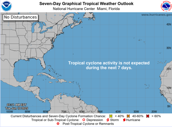
IN THE TROPICS: All is quiet and no tropical storm or hurricane development is expected in the Gulf of Mexico, Caribbean Sea, or the rest of the Atlantic the next seven days.
WORLD TEMPERATURE EXTREMES: Over the last 24 hours, the highest observation outside the U.S. was 119.3F at Dera Ismail Khan, Pakistan. The lowest observation was -99.0F at Vostok, Antarctica.
CONTIGUOUS TEMPERATURE EXTREMES: Over the last 24 hours, the highest observation was 121F at Death Valley, CA. The lowest observation was 30F at Peter Sinks, UT.
Category: Alabama's Weather, ALL POSTS, Social Media
About the Author (Author Profile)
Macon, Georgia Television Chief Meteorologist, Birmingham native, and long time Contributor on AlabamaWX. Stormchaser. I did not choose Weather, it chose Me. College Football Fanatic. @Ryan_StinnetSubscribe
If you enjoyed this article, subscribe to receive more just like it.


