Heat, Humidity, Storms… Your Typical Summer Forecast
FATHER’S DAY
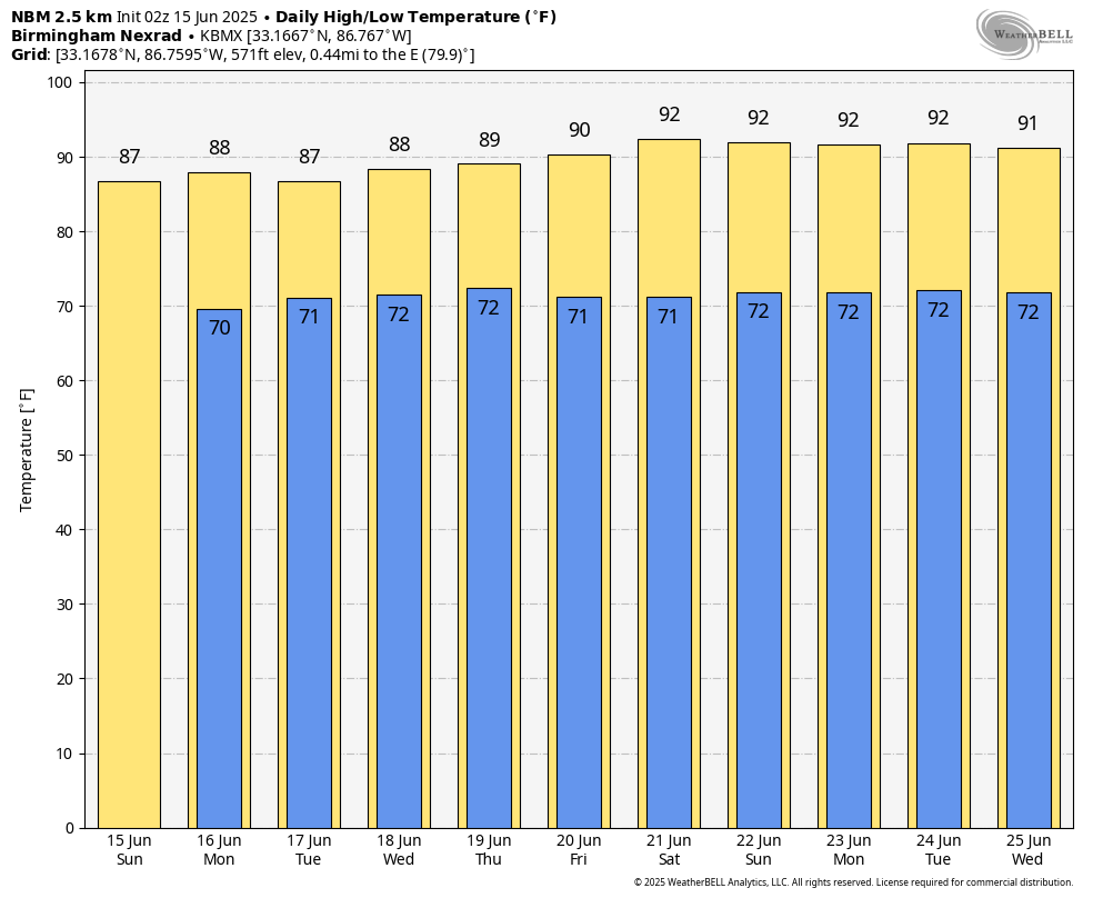
Sunday brings more of that classic summer feel across Central Alabama — warm and muggy with scattered afternoon and evening storms. We’re not expecting quite as many storms as Saturday thanks to weaker upper-level support, but the sea breeze will still spark some action, especially in southern parts of the state. Up north, pop-up storms will also be possible thanks to a juicy and unstable atmosphere. Highs will range from the mid 80s to the lower 90s.
A TYPICAL SUMMER WEATHER PATTERN FOR THE WORK WEEK AHEAD
Monday brings another round of scattered, heat-driven storms in the afternoon and evening hours. Moist air flowing in from the Gulf will keep the atmosphere unstable, and storms will flare up with the daytime heat. While these will be the usual pop-up type storms — heavy rain, brief lightning, and quick fades — a few could produce localized downpours. Highs will be in the mid to upper 80s to near 90.
Tuesday looks very similar to Monday, with a warm, moist, and unstable setup. Afternoon thunderstorms will once again develop across the area, especially during the peak heating hours. No organized severe threat, but just like Monday, some storms could be strong with heavy rain and gusty winds. This is your classic June weather pattern in Alabama. Highs will stay in the mid to upper 80s to around 90.
On Wednesday, the atmosphere settles down a bit as rain chances dip — likely the lowest of the week. Drier air begins to sneak in from the west, and while some isolated storms are still possible in the afternoon, coverage should be fairly limited. Humidity will remain high, but the change in pattern should give many folks a break from the thunder. Highs will climb into the upper 80s and lower 90s.
Thursday brings back scattered summer storms as the moisture returns and the heat cranks back up. Winds shift more out of the west, which often favors better storm development across the state. A few strong storms aren’t out of the question depending on how things evolve aloft, so we’ll be watching for any signs of more organized activity. Highs will land in the mid 80s to lower 90s.
By Friday, a big dome of high pressure starts to build in from the west, turning the heat up and nudging rain chances back down a bit. The air stays muggy, and afternoon storms will still form here and there, but they won’t be as widespread. It’s going to feel quite hot with heat indices pushing the upper 90s to near 100 in spots. Highs Friday will be in the upper 80s to lower 90s.
THE HEAT CRANKS UP FOR THE WEEKEND
Saturday is shaping up to be the hottest day of the week. That strong ridge of high pressure stays parked over the region, limiting storm chances and allowing temperatures to soar. With dewpoints still running high, it’s going to feel very steamy out there — classic Alabama summer. Expect highs to reach the lower to mid 90s.

THE TROPICS
For the North Atlantic, Caribbean Sea, and the Gulf of Mexico: Tropical cyclone formation is not expected during the next 7 days.
Category: Alabama's Weather, ALL POSTS, Social Media, Tropical, Weather Xtreme Videos
About the Author (Author Profile)
Scott Martin is an operational meteorologist, professional graphic artist, musician, husband, and father. Not only is Scott a member of the National Weather Association, but he is also the Central Alabama Chapter of the NWA president. Scott is also the co-founder of Racecast Weather, which provides forecasts for many racing series across the USA. He also supplies forecasts for the BassMaster Elite Series events including the BassMaster Classic.Subscribe
If you enjoyed this article, subscribe to receive more just like it.


