Monday Morning Weather Briefing Video: More Steamy Conditions and Storms Before Things Heat Up
I’m standing in for James Spann today, who is enjoying a well-deserved vacation. As we roll into the heart of June, the rhythm of the season takes hold across Alabama: hot, humid, and stormy. A moisture-rich atmosphere paired with subtle upper-level disturbances will bring scattered thunderstorms today, most likely during the afternoon and early evening. While widespread severe weather isn’t expected, the heat, humidity, and storm coverage will be enough to demand your attention if you’re planning to be outdoors.
SUNDAY RECAP AND MONDAY SETUP
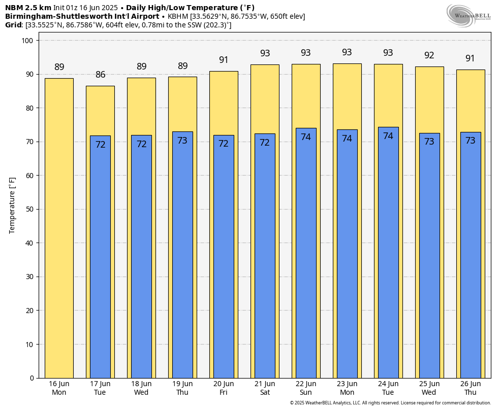
Storms on Sunday were driven by a modest upper-level trough and deep tropical moisture, producing scattered downpours, lightning, and gusty winds across much of Alabama. This morning, a few clouds linger, especially in central and eastern areas, but drier pockets are evident in the west. Temperatures are starting in the low to mid 70s and will climb into the upper 80s later today.
A weak shortwave over the Lower Mississippi Valley will move across Alabama this afternoon, bringing lift for convective development. Precipitable water values remain around 2 inches — plenty to fuel heavy rainfall. Shear is weak, but with instability growing through the day, pulse-type thunderstorms will flourish during peak heating hours.
TODAY AND TONIGHT
Skies will be partly sunny this morning with storms increasing by early afternoon. The best chance for rain (60–70%) comes between 1 PM and 7 PM, though some early showers can’t be ruled out in the west. Highs will reach the upper 80s. Southwest winds will blow around 5–10 mph. Storms will be capable of torrential downpours, frequent lightning, and gusty winds. After sunset, convection will gradually diminish, though some showers may linger. Overnight lows will fall into the lower 70s under mostly cloudy skies.
A LOOK THROUGH THE WEEK
Tuesday and Wednesday will be copy-paste days — mostly sunny mornings giving way to scattered storms in the afternoon. With the ridge still east of Alabama, moist southwest flow will keep us in a very humid pattern. Highs remain in the mid to upper 80s, and rain chances hover around 60–70% both days.
By Thursday, a weak trough associated with a surface low in the Great Lakes region may sweep through the Tennessee Valley, temporarily lowering rain chances by the weekend. Friday and Saturday could be a touch drier with more sun and fewer afternoon storms — though we’ll still keep a 30–40% chance each day. Highs may tick upward into the low 90s by Friday.
SOLSTICE COMING FRIDAY NIGHT
The summer solstice occurs this Friday evening at 9:41 PM CDT. That marks the official start of astronomical summer and the longest day of the year in terms of daylight. Alabama will enjoy nearly 14.5 hours of daylight on Friday — and it will certainly feel like summer.
SEVERE WEATHER OUTLOOK
No organized severe weather is expected across Alabama today. The Storm Prediction Center highlights an Enhanced Risk (level 3 of 5) for severe storms over parts of the Northern Plains and Upper Midwest. In our region, storms will be pulse-type with localized strong wind gusts possible during the afternoon, but no organized severe weather threat is present.
TROPICAL WEATHER OUTLOOK
The tropics remain quiet. The National Hurricane Center does not expect any tropical cyclone development over the next seven days in the Atlantic basin. A combination of dry air, Saharan dust, and strong upper-level winds is keeping conditions unfavorable for development — but we’re now in the early stages of the Atlantic hurricane season, which runs through November 30.
NATIONAL WEATHER HIGHLIGHTS
The weather headlines nationally center on a stalled front from the Mid-Atlantic to the Plains. Multiple areas are under a Slight Risk of Excessive Rainfall today, including the Mid-Atlantic, Central Appalachians, and Tennessee Valley. Enhanced Risk zones for severe storms exist across the Northern and Central Plains, where large hail and damaging winds are expected. In the Southwest, dangerously hot and dry conditions will continue with a Critical Risk of fire weather across parts of the Great Basin. Meanwhile, cooler air lingers across the Upper Midwest and Northeast behind the front.
DANCIN’ WITH THE STATS
Sunday brought the full spectrum of summer extremes — from a searing 122 degrees in Death Valley, California, to a downright chilly 28 degrees at a remote spot 19 miles east-southeast of Old Station, California, nestled in the higher elevations of the northern Sierra. From furnace blasts to frost-kissed breezes, California had it all!
BEACH FORECAST FOR ALABAMA AND NORTHWEST FLORIDA
It’s a beautiful start to the week along the Gulf Coast, but daily storm chances remain. Expect partly to mostly sunny mornings with increasing clouds and scattered thunderstorms during the afternoon and evening. Highs will be in the upper 80s with southwest winds 5–10 mph. Gulf water temperatures are in the mid 80s. Surf heights will be 1–2 feet. Rip current risk is LOW today but increases to MODERATE to HIGH midweek, especially on the Florida side. Use caution and heed local flag warnings. UV index values are in the extreme category — reapply sunscreen frequently.
WEATHERBRAINS PREVIEW
We recorded this week’s episode of WeatherBrains early — on Thursday night — due to James’ vacation. Our guest is Jeff Givens, better known as the Durango Weather Guy. He’s a popular amateur meteorologist from Colorado who shares insightful forecasts and commentary with a growing online following. Catch the show on YouTube at youtube.com/weatherbrains at 7 PM CDT Monday night, or download it anytime from your favorite podcast platform.
THIS DAY IN WEATHER HISTORY
Tropical Storm Agnes formed east of the Yucatán Peninsula on this date in 1972. After making landfall along the Florida Panhandle as a minimal hurricane, Agnes took on a second life. Her remnants rejuvenated over the Northeast, dumping torrential rainfall and causing record flooding from June 20–24 across Pennsylvania and New York.
Category: Alabama's Weather, ALL POSTS
About the Author (Author Profile)
Bill Murray is the President of The Weather Factory. He is the site's official weather historian and a weekend forecaster. He also anchors the site's severe weather coverage. Bill Murray is the proud holder of National Weather Association Digital Seal #0001 @wxhistorianSubscribe
If you enjoyed this article, subscribe to receive more just like it.


