Midday Nowcast: Humid with Afternoon and Evening Showers and Storms
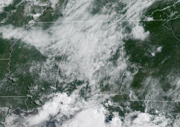
FINAL DAY OF JUNE: The weather is not changing much today, after starting the day off with the a partly sunny sky, we are watching the radar this afternoon as scattered to numerous showers and storms will begin to develop in the coming hours. Where storms develop, expect lots of lightning and torrential tropical downpours, along with gusty winds. Of course, an isolated severe storm or two cannot be ruled out. Highs today are generally in the upper 80s.
BIRMINGHAM ALMANAC: For June 30th, the average high for Birmingham is 90° and the average low is 71°. The record high is 104° set in 1931, while the record low is 53° set in 1923. We average 0.17” of precipitation on this date and the record value is 1.66” set in 1951.
ACROSS THE USA: Heat will build over the Intermountain West and the Southwest the next couple of days. Lightning from dry thunderstorms can create new fire starts and combined with gusty winds may cause a fire to rapidly grow in Oregon and northern California. Flash flooding will be possible in Arizona and west Texas today, as well as parts of the southern and central Plains due to slow moving thunderstorms.
HELLO JULY: Tomorrow and Wednesday, little change, daily scattered to numerous afternoon and evening storms with highs in the upper 80s. Loads of lightning and heavy rainfall with any storms which develop. Late Wednesday night, a surface front is forecast creep southward, reaching the far southern counties of the state Thursday morning. This will allow drier air to move into much of the state, meaning showers become few and far between Thursday and Friday with lots of sun and slightly higher heat levels. Highs will be in the low 90s for most places, but humidity levels will be down. The chance of thunderstorms Thursday and Friday is not zero, but generally less than 10%, but they should be very widely spaced, and mainly over the southern quarter of Alabama.
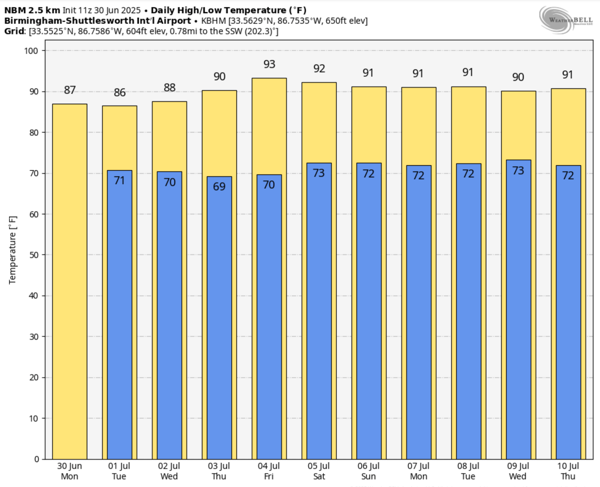
REST OF INDEPENDENCE DAY WEEKEND: Moisture levels will slowly rise, so we will mention the typical chance of a pop up afternoon shower or storm Saturday and Sunday; chance of any one spot seeing rain will be around 20% Saturday, and 30-40% Sunday. With a partly sunny sky, afternoon highs will be in the low 90s, right at seasonal averages.
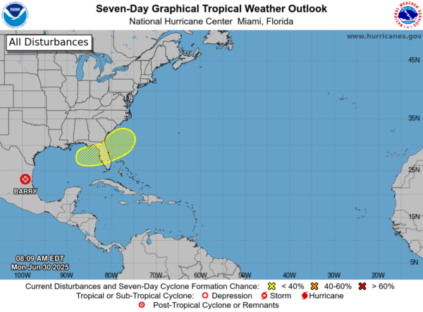
IN THE TROPICS: Barry has dissipated over Old Mexico. Near the Southeastern U.S., a frontal boundary is expected to stall and weaken off the southeast U.S. coast late this week. An area of low pressure could develop from the weakening front by the weekend off the southeast U.S., over Florida, or over the eastern Gulf. Some gradual tropical or subtropical development could occur thereafter as the low moves little. Formation chance through 7 days…low…20 percent. The next name up is Chantal. The rest of the Atlantic Basin is quiet.
WORLD TEMPERATURE EXTREMES: Over the last 24 hours, the highest observation outside the U.S. was 121.8F at Kuwait International Airport, Kuwait. The lowest observation was -95.9F at Concordia, Antarctica.
CONTIGUOUS TEMPERATURE EXTREMES: Over the last 24 hours, the highest observation was 115F at Topock, CA. The lowest observation was 27F at Peter Sinks, UT.
Category: Alabama's Weather, ALL POSTS, Social Media
About the Author (Author Profile)
Macon, Georgia Television Chief Meteorologist, Birmingham native, and long time Contributor on AlabamaWX. Stormchaser. I did not choose Weather, it chose Me. College Football Fanatic. @Ryan_StinnetSubscribe
If you enjoyed this article, subscribe to receive more just like it.


