Midday Nowcast: Quiet Radar for Now; Increasing Strong Storms this Afternoon
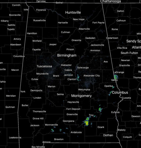
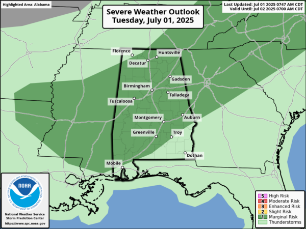
WELCOME TO JULY: Today and tomorrow, little change in the weather, daily scattered to numerous afternoon and evening storms with highs in the upper 80s. Loads of lightning and heavy rainfall with any storms which develop. Also, the SPC maintains a “marginal risk” (level 1 of 5) of severe storms today for much of Alabama as stronger storms today will be capable of producing damaging wind gusts and hail.
Of course a reminder, these storms are prolific rain producers and will produce areas of isolated flash flooding. Rain chances will begin to slowly decrease through the day tomorrow, with more of the widespread rain and storms across southern portions of the state.
BIRMINGHAM ALMANAC: For July 1st, the average high for Birmingham is 90° and the average low is 71°. The record high is 104° set in 2012, while the record low is 54° set in 1950. We average 0.18” of precipitation on this date and the record value is 2.67” set in 2003.
MORE JULY CLIMATE DATA: As we head deeper into July and approach the “Dog Days of Summer” temperatures stay hot. To start the month, the average high is 90°, by the end of the month the average high is 91°. The hottest temperature for the month of July was 107° in 1930, and is actually the hottest temperatures ever recorded for the City of Birmingham. Additionally, July is one of our wettest months in the city, it is actually second behind only March. We average 5.38” inches of rain, a lot of which comes from daily storms but also the occasional early season tropical system. The wettest July was in 1916 when the city received 20.12” of rain, and is the wettest month ever recorded for the city. The driest July on record was 1983 when only 0.30” of rain was received.
THROUGH INDEPENDENCE DAY WEEKEND: Late Wednesday night, a surface front will creep southward, reaching the far southern counties of the state Thursday morning. This will allow drier air to move into much of the state, meaning showers become few and far between Thursday, Friday, and Saturday. Expect lots of sunshine and slightly higher heat levels. Highs will be in the low 90s for most places, but humidity levels will be down. The chance of thunderstorms Thursday through Saturday is not zero, but generally less than 10%, but they should be very widely spaced, and mainly over the southern quarter of Alabama. Rain chances will be slightly higher on Sunday as we watch the stalled front in the northern Gulf.
NEXT WEEK: Moisture levels will continue to slowly rise, and the week will feature very routine summer weather. Partly sunny days with scattered, mostly afternoon and evening showers and thunderstorms. Highs will be close to 90 degrees, which is right where temperatures should be for early July in Alabama.
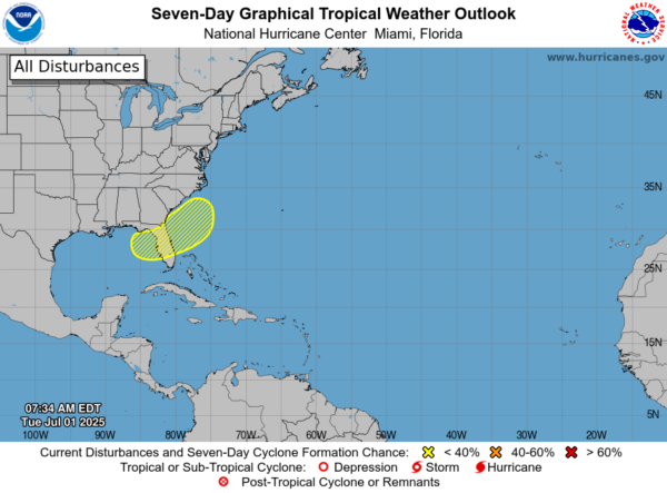
IN THE TROPICS: As the front stalls off the coast near the Southeastern U.S. late this week, an area of low pressure could develop from the weakening front by the weekend over the Atlantic waters off the southeast U.S., over Florida, or over the eastern Gulf. Some gradual tropical or subtropical development could occur thereafter as the low drifts and moves little. Formation chance through 7 days…low…30 percent. The next name up is Chantal. The rest of the Atlantic Basin is quiet.
WORLD TEMPERATURE EXTREMES: Over the last 24 hours, the highest observation outside the U.S. was 120.7F at King Fahad International Airport, Saudi Arabia. The lowest observation was -99.8F at Vostok, Antarctica.
CONTIGUOUS TEMPERATURE EXTREMES: Over the last 24 hours, the highest observation was 119F at Topock, CA. The lowest observation was 33F at Calpet, WY.
Category: Alabama's Weather, ALL POSTS, Social Media
About the Author (Author Profile)
Macon, Georgia Television Chief Meteorologist, Birmingham native, and long time Contributor on AlabamaWX. Stormchaser. I did not choose Weather, it chose Me. College Football Fanatic. @Ryan_StinnetSubscribe
If you enjoyed this article, subscribe to receive more just like it.


