Midday Nowcast: Hot and Mainly Dry through Independence Day Weekend
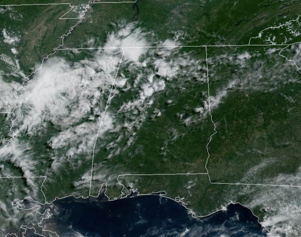
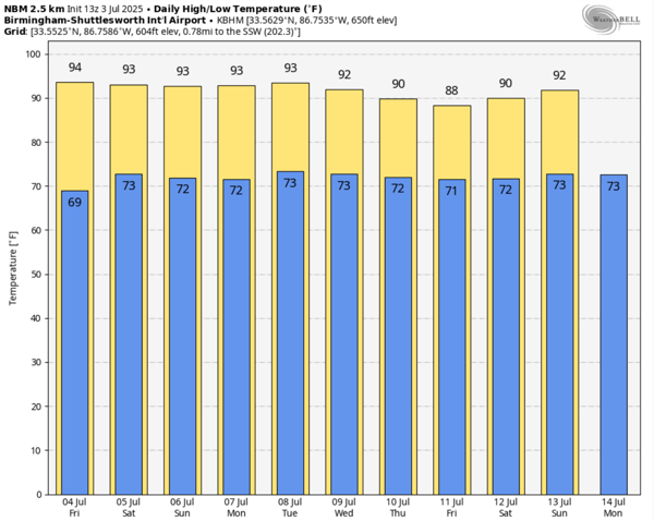
HOT & MAINLY DRY: With the drier in place, showers if any, will be few and far between through Sunday. Expect lots of sunshine and slightly higher heat levels. Highs will be in the low 90s for most places, but humidity levels are down. The chance of thunderstorms through Sunday is not zero, but generally less than 10%. Any and all Independence Day festivities whether grilling out, hitting a body of water to cool off, or fireworks, should not have any weather issues this year.
BIRMINGHAM ALMANAC: For July 3rd, the average high for Birmingham is 90° and the average low is 71°. The record high is 101° set in 1970, while the record low is 57° set in 1924. We average 0.18” of precipitation on this date and the record value is 2.76” set in 1940.
NEXT WEEK: Moisture levels will rise, and the week will feature very routine summer weather. Partly sunny days with scattered, mostly afternoon and evening showers and thunderstorms. Highs will be close to 90 degrees, which is right where temperatures should be for early July in Alabama. For the second half of next week, showers and storms should become a bit more numerous and widespread in coverage.
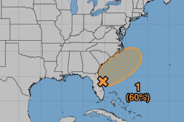
IN THE TROPICS: Off the Southeast Coast of the U.S., an area of low pressure is forecast to develop along a weakening frontal boundary near Florida or the Atlantic coast of the southeastern United States by Saturday. Environmental conditions appear only marginally conducive for some slow development, but a tropical or subtropical depression could form in this region over the weekend or early next week while the system drifts northward or northeastward. Regardless of development, heavy rainfall is possible across portions of the southeast U.S., particularly across the west-central Florida coast. Formation chance through 48 hours…low…20 percent. Formation chance through 7 days…medium…60 percent. The next name up is Chantal. The rest of the Atlantic Basin is quiet.
BEACHBOUND: Great weather along the Alabama and Northwest Florida Gulf Coast through the weekend. Highs will be in the low 90s, and the days will feature more sun than clouds. That is causing the UV Index to be extreme, so wear lots of sunscreen. The risk of rip currents is low, however, life threatening rip currents may still occur especially near jetties, reefs, and piers. Always swim near a lifeguard and remember to heed the advice of the local beach patrol and flag warning systems. And know near the Panama City area, the rip current threat is moderate. That portion of the Gulf Coast always has higher rip currents than the rest of the coast due to the northwest to southeast layout of the shore. Water temperatures up and down the coast are in the mid-80s, which are perfect for me! Rain chances will start to increase by the end of the weekend.
WORLD TEMPERATURE EXTREMES: Over the last 24 hours, the highest observation outside the U.S. was 120.4F at Zabol, Iran. The lowest observation was -99.9F at Concordia, Antarctica.
CONTIGUOUS TEMPERATURE EXTREMES: Over the last 24 hours, the highest observation was 110F at Death Valley, CA. The lowest observation was 35F at Redfeather Lakes, CO.
Category: Alabama's Weather, ALL POSTS, Social Media
About the Author (Author Profile)
Macon, Georgia Television Chief Meteorologist, Birmingham native, and long time Contributor on AlabamaWX. Stormchaser. I did not choose Weather, it chose Me. College Football Fanatic. @Ryan_StinnetSubscribe
If you enjoyed this article, subscribe to receive more just like it.


