Midday Nowcast: Classic July Weather; Watching the Northern Gulf
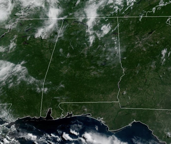
DOG DAYS OF SUMMER: Hot and humid days with highs in the mid 90s for much of Alabama and when you add in those high humidity levels, heat index values are in the upper 90s and low 100s. The only heat relief will come from a few afternoon and evening showers and thunderstorms in random spots. Rain chances the next couple or days are only in the 20-30% range, but will increase to the 50-70% range by the end of the week.
BIRMINGHAM ALMANAC: For July 14th, the average high for Birmingham is 91° and the average low is 72°. The record high is 103° set in 1980, while the record low is 57° set in 1967. We average 0.17” of precipitation on this date and the record value is 2.70” set in 1950.
ACROSS THE USA: Widespread heavy rainfall with the potential for numerous instances of flash flooding along the I-95 corridor in the Mid-Atlantic Monday. Heavy rainfall and flash flood threat for Florida Monday-Tuesday. Increasing thunderstorm chances across portions of the north-central U.S. with flash flooding and severe weather expected Tuesday. Uncomfortable heat remains in place across much of the eastern and western U.S.
THE ALABAMA WEEKEND: This classic summer weather pattern continues with morning sunshine, followed by scattered afternoon and evening storms. Most of the storms will come from 1PM-10PM. High over the weekend will be in the low 90s. The pattern will likely continue through most of next week; we are in that time of the year when the weather simply doesn’t change much, unless we get a tropical system.
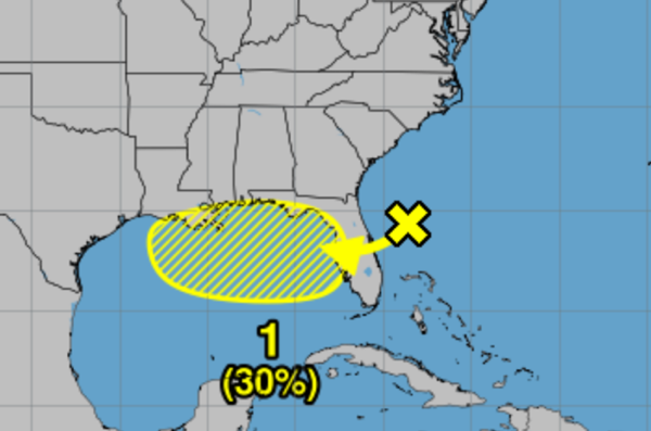
IN THE TROPICS: X marks the spot, as we are watching an area of low pressure located offshore the east coast of Florida is producing disorganized showers and thunderstorms this morning.
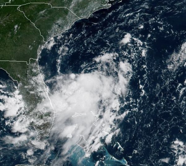
This disturbance is forecast to move westward across Florida during the next day or so, and into the northeastern Gulf by late Tuesday. Environmental conditions appear favorable and some gradual development of this system is possible while it moves westward to west-northwestward across the northeastern and north-central portions of the Gulf during the middle to latter part of this week. Regardless of development, heavy rainfall could produce localized flash flooding over portions of Florida and the north-central Gulf coast through the middle to latter portion of this week.
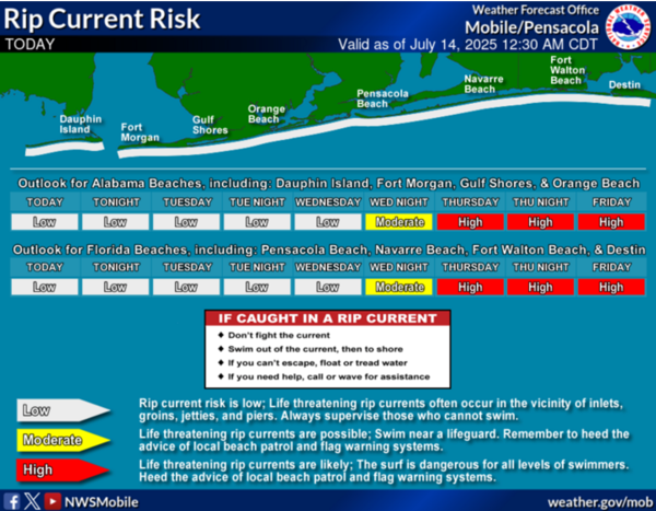
Also, rip currents are going to be in the high. Formation chance through 7 days…low…30 percent. Next name up is Dexter.
WORLD TEMPERATURE EXTREMES: Over the last 24 hours, the highest observation outside the U.S. was 123.3F at Basrah International Airport, Iraq.The lowest observation was -99.2F at Vostok, Antarctica.
CONTIGUOUS TEMPERATURE EXTREMES: Over the last 24 hours, the highest observation was 122F at Tecopa, CA. The lowest observation was 31F at Peter Sinks, UT.
Category: Alabama's Weather, ALL POSTS, Social Media, Tropical
About the Author (Author Profile)
Macon, Georgia Television Chief Meteorologist, Birmingham native, and long time Contributor on AlabamaWX. Stormchaser. I did not choose Weather, it chose Me. College Football Fanatic. @Ryan_StinnetSubscribe
If you enjoyed this article, subscribe to receive more just like it.


