Storms More Numerous By Thursday/Friday
RADAR CHECK: Showers so far today are few and far between across Alabama; most places are dry with temperatures in the 89-94 degree range for most places. Isolated showers will end after sunset.
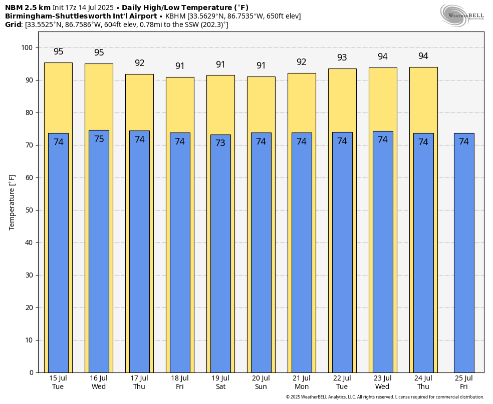
Classic summer weather continues across Alabama tomorrow and Wednesday with partly sunny, hot, humid days and a few afternoon and evening showers and thunderstorms in random spots. Highs will be in the mid 90s in most locations; some of the hottest weather we have experienced so far this summer.
The upper ridge over the region will weaken by Thursday and Friday, and we expect an increase in the number of afternoon showers and thunderstorms with highs in the 88-92 degree range. Chance of any one spot getting wet through Wednesday is 20-30 percent, and 50-60 percent Thursday and Friday.
THE ALABAMA WEEKEND: Classic summer weather continues with morning sun and scattered afternoon and evening storms. Most of the storms will come from 1:00 until 10:00 p.m… and highs over the weekend will be in the low 90s. The pattern will likely continue through most of next week; we are in that time of the year when the weather simply doesn’t change much. See the video briefing for maps, graphics, and more details.
TROPICS: An area of low pressure located offshore of the east coast of Florida is producing disorganized showers and thunderstorms. This disturbance is forecast to move westward across Florida during the next day or so, and into the northeastern Gulf by late Tuesday. Environmental conditions appear favorable and some gradual development of this system is possible while it moves westward to west-northwestward across the northeastern and north-central portions of the Gulf during the middle to latter part of this week. NHC gives this a 30 percent chance of development.
Global models are not showing any major development at this point. This feature will likely bring elevated coverage of showers and storms along the Central Gulf Coast at any given point for a day or two, but odds of this becoming a strong tropical storm or hurricane are very low. There will be intervals of sunshine.
The main concern is a high rip current danger Thursday and Friday.
ON THIS DATE IN 1995: On the evening of Friday, July 14th, thunderstorms producing severe weather were occurring over Upper Michigan and adjacent portions of Ontario near Sault Saint Marie. By late evening the storms had evolved into a bowing line just northwest of the Mackinac Bridge. At 10:17 PM EDT, the thunderstorm gust front hit the bridge, and a gust to 90 mph was measured. Sustained winds of 80 mph continued on the bridge for ten more minutes. Thus began the intense “Ontario-Adirondacks Derecho” that would cause hundreds of millions of dollars’ worth of damage, several deaths, and many injuries as it raced southeast from the northern Great Lakes to the Atlantic coast.
Look for the next video briefing here by 6:00 a.m. tomorrow…
Category: Alabama's Weather, ALL POSTS, Weather Xtreme Videos
About the Author (Author Profile)
James Spann is one of the most recognized and trusted television meteorologists in the industry. He holds the AMS CCM designation and television seals from the AMS and NWA. He is a past winner of the Broadcast Meteorologist of the Year from both professional organizations.Subscribe
If you enjoyed this article, subscribe to receive more just like it.


