Hot, Humid Days; Eyes On The Northern Gulf
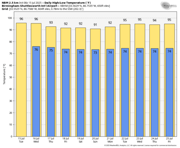
HOT, HUMID SUMMER WEATHER: Alabama’s weather won’t change much through tomorrow. Partly to mostly sunny, hot, humid days with just a few isolated afternoon showers and storms; highs will be in the mid 90s for most places.
We expect a general increase in the number of scattered showers and thunderstorms Thursday through the weekend, with some of the highest coverage over the southern third of the state as a broad low/potential tropical depression moves through the northern Gulf. But, even there it won’t rain all day and the sun will be out at times. Most (but not all) of the showers and storms will come during the afternoon and evening hours, between 1:00 and 10:00 p.m. Heat levels will be a tad lower with highs in the 89-93 degree range.
And, for next week, the weather looks very routine for summer. Partly sunny days with the risk of a passing afternoon shower or thunderstorm in scattered spots. Highs rise back into the mid 90s… See the video briefing for maps, graphics, and more details.
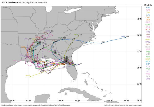
TROPICS: Recent satellite-derived wind data indicate that the area of low pressure (Invest 93L) located just offshore of the east coast of Florida is gradually becoming better defined. However, the shower and thunderstorm activity remains disorganized. This system is forecast to move westward across the Florida Peninsula today and tonight, then reach the northeastern Gulf by the middle part of this week.
Environmental conditions appear generally favorable for additional development, and a tropical depression could form by the middle to latter part of this week as the system moves across the northeastern and north-central Gulf. NHC gives it a 40 percent chance of development.
This will be mainly a rainmaker; models continue to show little development. It is very unlikely that this becomes a strong tropical storm or hurricane. For the central Gulf coast (Gulf Shores to Panama City Beach), there will be a day or two later this week with elevated coverage of showers and thunderstorms, but even on those days the rain won’t be continuous, and the sun will be out at times. Keep in mind this feature will be moving westward (it won’t be stationary), so the weather on the coast will improve by the weekend as the system moves into Louisiana. Don’t change your plans if you have a beach trip.
The biggest concern is a high danger of rip currents on the coast Thursday and Friday.
ON THIS DATE IN 1901: The city of Marquette, Michigan set their all-time record high temperature with 108-degree reading.
ON THIS DATE IN 2003: Hurricane Claudette made landfall along the middle Texas coast near Port O’Connor at category one strength. Claudette was the first hurricane to strike the Port O’Connor and Matagorda Bay area since Hurricane Fern on September 10, 1971. Historical records dating back to 1851 indicate Claudette is the first July hurricane to make landfall in this area.
Look for the next video briefing here by 3:00 this afternoon… enjoy the day!
Category: Alabama's Weather, ALL POSTS, Weather Xtreme Videos


