Midday Nowcast: Higher Rain Chances to End the Week; Watching the Northern Gulf Carefully
THE HEAT GOES ON: Hot, humid days with highs in the mid to upper 90s for much of Alabama, factor in those high humidity levels, heat index values are in the low 100s. The only heat relief will come from a few afternoon and evening showers and thunderstorms in random spots. Rain chances today and tomorrow are only in the 20-30% range, but will increase to the 50-70% range by the end of the week and afternoon highs should drop back into the low 90s.
BIRMINGHAM ALMANAC: For July 15th, the average high for Birmingham is 91° and the average low is 72°. The record high is 102° set in 1980, while the record low is 51° set in 1967. We average 0.18” of precipitation on this date and the record value is 2.00” set in 1923.
USA BRIEF: Heavy rainfall/flash flood risk continues for portions of the Mid-Atlantic/Appalachians into mid-week. Heavy downpours and possible flash flooding expected with tropical disturbance crossing the Florida Peninsula Tuesday. Potent Summer storm system will bring the threat of flash flooding and severe weather to the Midwest and northern/central Plains the next couple of days. Increasing heat threat across much of the eastern U.S. through at least mid-week.
WEEKEND AND BEYOND: This classic summer weather pattern continues with morning sunshine, followed by scattered afternoon and evening storms. Most of the storms will come from 1PM-10PM. High over the weekend will be in the low 90s. Of course there will a higher coverage of rain and storms over the southern third of the state as a broad low/potential tropical depression moves through the northern Gulf. But, even there it won’t rain all day and the sun will be out at times. The main threat will be a high rip current threat, so pay attention to the rip current flag warning system up and down the coast. The pattern will likely continue through most of next week; we are in that time of the year when the weather simply doesn’t change much, but of course we will have to keep an eye on the remnants of the tropical system after it makes landfall in Louisiana.
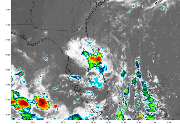
DEXTER, IS THAT YOU?: East of the Florida Peninsula into the Northeastern Gulf Invest 93L is what we are watching. Satellite and radar data indicate that the shower and thunderstorm activity associated with the low pressure located just offshore of the east coast of Florida remains disorganized. This system is forecast to move westward across the Florida Peninsula today and then reach the northeastern Gulf tomorrow. Environmental conditions appear generally favorable for additional development, and a tropical depression could form while the system moves across the northeastern and north-central Gulf.
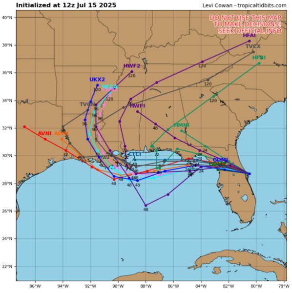
Regardless of development, heavy rainfall could produce localized flash flooding over portions of Florida through mid-week. Heavy rainfall could also cause flash flooding for portions of the north-central Gulf Coast during the middle to latter portions of this week. Formation chance through 48 hours…medium…40 percent.
WORLD TEMPERATURE EXTREMES: Over the last 24 hours, the highest observation outside the U.S. was 122.4F at Abadan, Iran. The lowest observation was -102.3F at Vostok, Antarctica.
CONTIGUOUS TEMPERATURE EXTREMES: Over the last 24 hours, the highest observation was 124F at Death Valley, CA. The lowest observation was 32F at Peter Sinks, UT.
Category: Alabama's Weather, ALL POSTS, Social Media, Tropical
About the Author (Author Profile)
Macon, Georgia Television Chief Meteorologist, Birmingham native, and long time Contributor on AlabamaWX. Stormchaser. I did not choose Weather, it chose Me. College Football Fanatic. @Ryan_StinnetSubscribe
If you enjoyed this article, subscribe to receive more just like it.


