Midday Nowcast: Heat Advisory Continues for Portions of Alabama; Expect Some Afternoon Storms
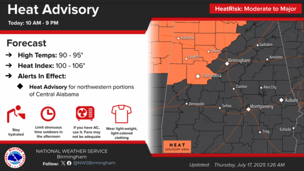
HOT WITH SOME STORMS: Hot and humid weather with highs in the mid 90s for most of Alabama today. Heat index values are ranging from 100°-107° across the state; anything over 105° is in the danger range for the northern two-thirds of Alabama and the Heat Advisory continues today for portions of West and North Alabama. Just an FYI, for areas across South Alabama, the danger range for a Heat Advisory starts when heat index values are 108° or greater.
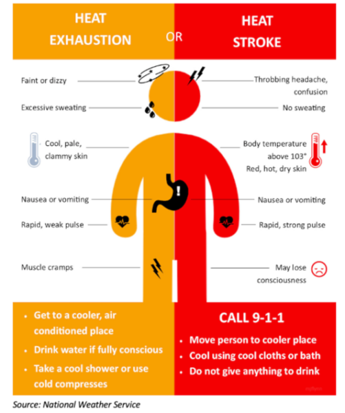
We all know how to stay cool, but here is a reminder of heat illnesses and if you feel any of these symptoms, take action immediately. In case you didn’t know, heat is the number one weather related killer each year, so take it seriously.
The only heat relief will come from some afternoon and evening showers and thunderstorms in random spots. Rain chances today and tomorrow are slightly higher than previous days, in the 40%-60% range, mainly due to the tropical feature moving through the Northern Gulf. The highest rain chances will be across the southern sections of the state both days. Highs tomorrow, should drop back into the lower 90s, with more clouds and those higher rain chances.
BIRMINGHAM ALMANAC: For July 17th, the average high for Birmingham is 91° and the average low is 72°. The record high is 105° set in 1980, while the record low is 60° set in 2014. We average 0.19” of precipitation on this date and the record value is 1.74” set in 1916.
IN THE TROPICS: Invest 93L continues to track westward but chances for development are decreasing as it is running out of time before moving inland. Satellite, surface, and radar data indicate that the broad low pressure area over northern Gulf is located just south of the coast of Mississippi. The associated shower and thunderstorm activity remains disorganized and located mainly to the west and southwest of the center. Some development could occur before the system moves westward into Louisiana later today or tonight, although the chances of the system developing into a tropical depression are low.
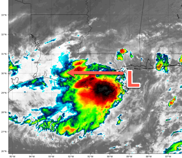
Regardless of development, heavy rainfall could produce localized flash flooding over portions of the north-central Gulf Coast through Friday. For additional information, please refer to products issued by the Weather Prediction Center and your local National Weather Service office. Formation chance through 48 hours…low…30 percent. The rest of the Atlantic is quiet for now.
USA BRIEF: Active thunderstorm pattern will bring the threat of flash flooding and severe weather along a slow moving cold front stretching from the Northeast/Mid-Atlantic to the central Plains. Slow moving low to bring significant heavy rainfall and scattered to numerous instances of flash flooding to the Central Gulf Coast. Widespread major heat risk across the East Coast, Ohio Valley, Southeast, and Lower Mississippi Valley.
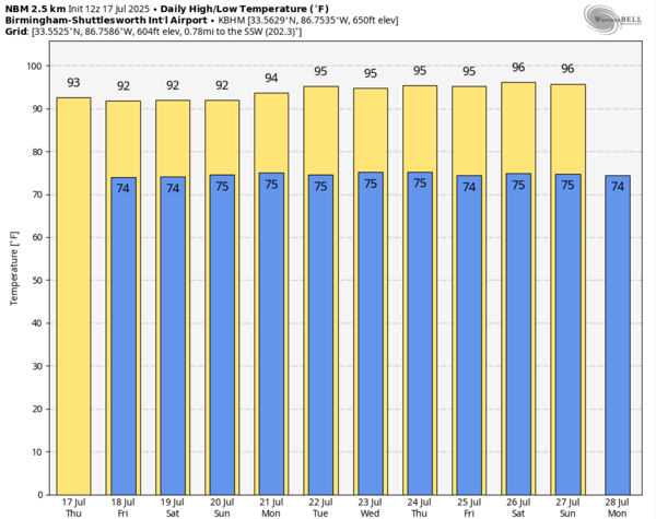
WEEKEND AND BEYOND: This classic summer weather pattern continues with morning sunshine, followed by scattered afternoon and evening storms. Summertime storms are what we call airmass thunderstorms, and with hot temperatures and high humidity, daytime heating is the main reason the storms develop as instability value peak during the afternoon and evening hours, 1 p.m.-10 p.m. Highs over the weekend will be in the low 90s. The pattern will likely continue through most of next week, as we are in the “Dogs Days of Summer.” It is the time of the year when the weather simply doesn’t change much, however, we note afternoon highs will be hotter next week as an upper ridge begins to build in over the Deep South. An upper ridge causes sinking air, which heats up more as it compresses. Highs look to be in the mid to upper 90s.
The sinking air can suppress shower and thunderstorm development, and rain chances will decrease to the 20%-30%, but with so much instability available this time of year as dew points are in the low to mid 70s, rain chances are rarely zero in the summer.
“DOG DAYS OF SUMMER”: The “Dog Days of Summer” refer to the hottest, most stifling stretch of the summer season, traditionally observed from July 3 to August 11 in the Northern Hemisphere.The name originates from ancient Greek and Roman astronomy and astrology, when people noticed that this period coincided with the heliacal rising of Sirius (the Dog Star), the brightest star in the night sky, located in the constellation Canis Major—Latin for “Greater Dog.”

Ancient cultures believed that the combined heat of the Sun and Sirius was responsible for the oppressive weather, and as a result, the season became associated with drought, disease, lethargy, and even madness. In classical and medieval folklore, the Dog Days were seen as an unlucky time when dogs were more likely to go mad, wine would sour, and tempers ran high.
Today, while the literal link to Sirius is mostly symbolic, the term persists in popular culture as a way to describe the dragging, sweltering days of late summer when energy feels low and the heat seems endless.
BEACHBOUND: Life-threatening rip currents continue from Dauphins Island east to Panama City, making for dangerous conditions for swimmers of all skill levels the next couple of days.
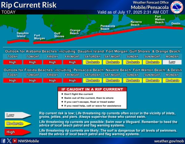
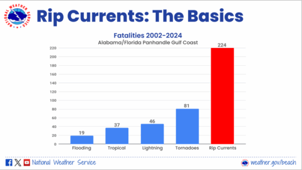
Local authorities are urging individuals to stay out of the water and to follow the guidance of local beach patrols and flag warning systems. Rip currents should decrease to moderate by Saturday and Sunday, but precautions are still needed. A reminder that rip currents are the number one weather related killer for along the Alabama and Northwest Florida Gulf Coast, areas converge by the National Weather Service Offices in Mobile and Tallahassee.
This weekend at the beach will bring warm water temperatures in the mid-80s, but also a mix of sun and storms. Today and tomorrow are expected to be the stormiest, with widespread showers and thunderstorms likely throughout both days, especially in the morning and afternoon. Rain chances are high—around 90%—with daytime highs in the upper 80 and breezy south winds. Friday night should calm down a bit, with only a slight chance of storms and partly cloudy skies.
Saturday will start off with showers and possible thunderstorms, mainly in the morning, but the skies are expected to turn mostly sunny by the afternoon. There’s a 70% chance of rain early in the day, with a high near 90 degrees and lighter winds. Saturday night looks mostly clear and pleasant. On Sunday, the forecast includes a 40% chance of scattered showers and thunderstorms, but otherwise, it should be sunny and hot with a high near 90 degrees. Overall, expect a wet start to the weekend with improving conditions by Saturday afternoon into Sunday—bring both sunscreen and rain gear just in case.
The UV index is at a very high level. “Very high risk of harm from unprotected sun exposure”. Take extra precautions, as unprotected skin can be damaged and burn quickly. Minimize sun exposure between 10 a.m. and 4 p.m., seek shade, cover up, wear a hat and sunglasses, and use sunscreen.
WORLD TEMPERATURE EXTREMES: Over the last 24 hours, the highest observation outside the U.S. was 124.0F at Basrah International Airport, Iraq. The lowest observation was -96.3F at Vostok, Antarctica.
CONTIGUOUS TEMPERATURE EXTREMES: Over the last 24 hours, the highest observation was 116F at Stovepipe Wells, CA. The lowest observation was 29F at Mackay, ID.
Category: Alabama's Weather, ALL POSTS, Social Media
About the Author (Author Profile)
Macon, Georgia Television Chief Meteorologist, Birmingham native, and long time Contributor on AlabamaWX. Stormchaser. I did not choose Weather, it chose Me. College Football Fanatic. @Ryan_StinnetSubscribe
If you enjoyed this article, subscribe to receive more just like it.


