Partly Sunny Days; Scattered Afternoon Showers/Storms
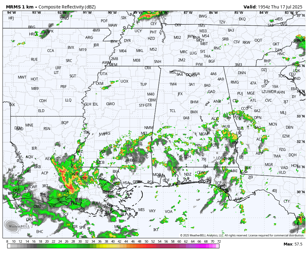
RADAR CHECK: As you expect on a summer afternoon in Alabama… we have scattered showers and storms in progress this afternoon. They are most numerous over the southern half of the state, and are moving northward on the east side of the broad tropical low over Louisiana. Tempeartures are generally below average for mid-July with most places in the 85-92 degree range. Showers will fade tonight after dark.
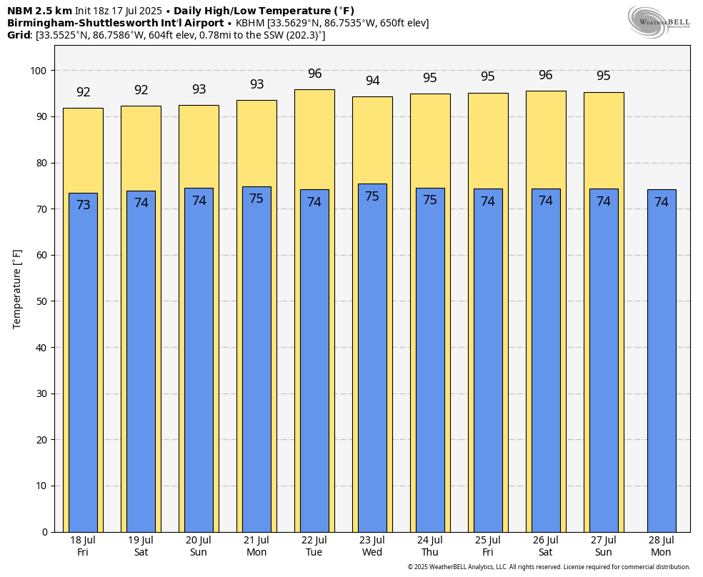
This is the time of the year when the weather just doesn’t change much. You can say “hot and humid with an afternoon thunderstorm in spots” and be right almost every day. And, that is our situation through next week. The average high for Birmingham on July 17 is 91, and we expect highs generally in the low 90s tomorrow through the weekend, right where we should be for this time of the year.
Coverage of afternoon/evening showers and storms will be a little higher tomorrow and over the weekend, but it won’t rain everywhere. Most (but not all) of the showers will come from around 1:00 until 10:00 p.m. The sky will be partly sunny; the chance of any one given location seeing rain will be in the 35-45 percent range.
With a stronger upper ridge afternoon highs will likely be in the mid 90s on most days next week with just a few isolated afternoon and evening showers and storms around. See the video briefing for maps, graphics, and more details.
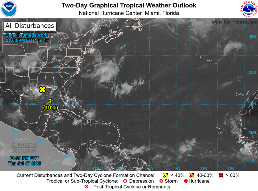
TROPICS: Satellite, surface, and radar data indicate that the broad low pressure area is moving inland over southeastern Louisiana, and that the associated shower and thunderstorm activity remains disorganized and located mainly to the west and southwest of the center. Little development is expected while the center remains near the coast this afternoon and tonight, and the system is expected to weaken as it moves farther inland on Friday.
The chance of development has dropped to 10 percent. The only signifiant impact for the Central Gulf Coast is a high danger of rip currents through tomorrow. The rest of the Atlantic basin remains very quiet.
ON THIS DATE IN 1942: A great flood developed over the Smethport area in Pennsylvania, resulting in an estimated 34.50 inches of rain in just one day, including 30.60 inches in only six hours, setting a world record. The official observing site, Smethport Highway Shed, reported only 13.08 inches for the entire month because the flood consumed the gauge after 6.68″ of rain. The total results from the substitution of the officially estimated amount for the amount measured.
ON THIS DATE IN 1987: Slow moving thunderstorms caused flooding on the Guadalupe River in Texas resulting in tragic loss of life. A bus and van leaving a youth summer camp stalled near the rapidly rising river, just west of the town of Comfort, or about 50 mile northwest of San Antonio. The powerful surge of water swept away 43 persons, mostly teenagers. Ten drowned in the floodwaters. Most of the others were rescued from treetops by helicopter. This event was very similar to the flood tragedy in the same spot two weeks ago.
Look for the next video briefing here by 6:00 a.m. tomorrow…
Category: Alabama's Weather, ALL POSTS, Weather Xtreme Videos
About the Author (Author Profile)
James Spann is one of the most recognized and trusted television meteorologists in the industry. He holds the AMS CCM designation and television seals from the AMS and NWA. He is a past winner of the Broadcast Meteorologist of the Year from both professional organizations.Subscribe
If you enjoyed this article, subscribe to receive more just like it.


