Oil Spill
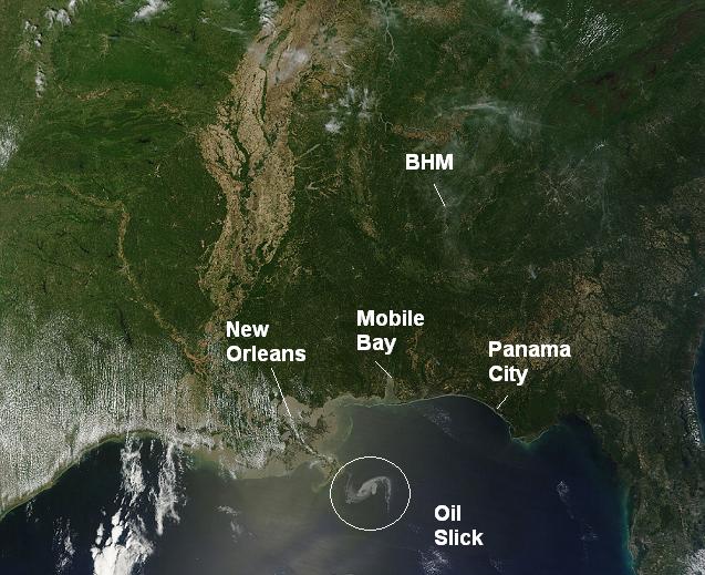
This satellite image from yesterday shows the oil spill off the Louisiana Coast resulting from the explosion and sinking of the Deepwater Horizon Oil Rig. Late reports last night indicated that the oil had reached the mouth of the Mississippi River.
The leak is reportedly 5,000 barrels per day, or about 200,000 gallons. If you think about it by volume, this doesn’t seem like a lot. A 1 acre lake, 4 feet deep, contains 1.4 million gallons of water. So, it would take a week of the oil leak continuing to fill up a small lake. But, oil is less dense than water, with a density 87% what water is. So, the oil floats up on top of the water and spreads out quickly (a drop of gasoline spilled in a lake can create a slick 1 foot across). So far, the oil slick has covered hundreds of square miles.
I’m not an oceanographer, but I do understand that the wind plays a major role in where the oil goes. Until yesterday, most of the oil had stayed out in the open ocean. However, SE winds have picked up ahead of the next slow-moving storm system to affect the region, and this is moving some of the oil toward the Louisiana Coast. Some computer models indicate, and it makes sense given the winds over the Gulf, that the oil will continue to move toward Louisiana and eventually Mississippi this weekend, and could reach the Alabama or Florida coast early next week. But, like I said, I’m not an oceanographer, and there are websites out there tracking the oil.
Governor Riley said today that booms, or floating devices that contain oil spills, are being deployed to try to keep the oil from reaching the Alabama shoreline. I hope it works. Other options that have been tried are burning off some of the oil, and aerial spraying of dispersive liquids (soap?). In any event, this will likely be an environmental disaster somewhere along the coast.
Category: Uncategorized


