Ice Bowl?

We have been discussing the gathering cold air over Canada for the past week or so. The above map shows current temperatures, and everywhere north of the light blue is in the 10s or lower, with some stations way below zero. This dense cold air is producing high pressure at the surface and a strong jet stream aloft (between it and the warmer air over the US), a classic set up for this cold air to come south sometime in the next few days.
It looks like a large upper-level disturbance will break it loose early next week, with both the GFS and the European models showing an Arctic cold front moving southeast across the central and eastern US next week. The cold front will make it into Alabama on Thanksgiving Day, with temperatures falling through the 40s and wind chills near freezing.
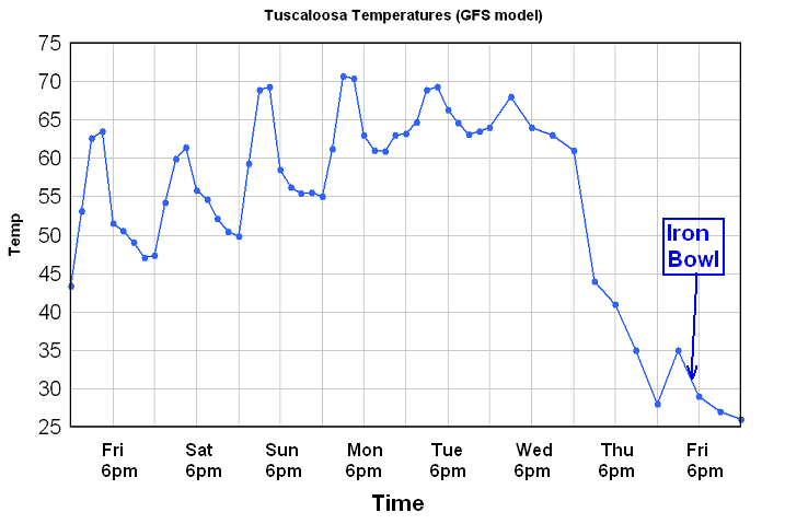
The next day is the Iron Bowl at Bryant-Denny Stadium. This could be one of the coldest Iron Bowls in a long time, at least since 2000, when light snow, rain, and sleet fell at times with temperatures in the 30s. Here is the current raw GFS prediction for temperatures in Tuscaloosa for the next week.

Notice how fast temperatures fall on Thursday, with highs only in the 30s on Friday. It will also be windy, so if the models are right, wind chills during the game could be in the 20s!
It’s still a week away, but we’ve been watching this setup for a week, and that much cold air over Canada, being so heavy, has to eventually spread out. It is possible that it will be more concentrated to our north and get pushed into New England, so we’ll have to see how good the models are. Stay tuned…
Category: Alabama's Weather
About the Author (Author Profile)
Subscribe
If you enjoyed this article, subscribe to receive more just like it.


