Early Morning Look at Southern Weather
Good morning. Brian Peters will be along with updated thoughts in a few minutes and a more detailed analysis. But here are a few notes.
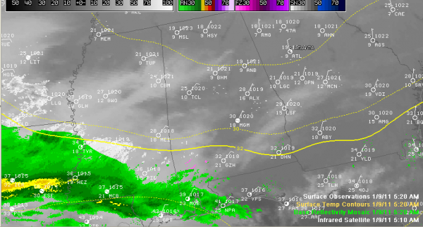
This image says a lot on a Sunday morning.
1. It’s cold! 22F at Birmingham, 18F at Huntsville. About where we expected things to be.
2. Very dry Arctic airmass: single digit dew points including 8F at Birmingham. (It will take atmosphere a while to moisten up when precipitation starts falling from above, so you will see virga)
3. This is evidenced in the radar returns, which show lots of precipitation over Louisiana and southwestern Mississippi, edging into Southwest Alabama. Most of this is not reaching the ground, as evidenced by the surface obs that show no precipitation. You have to get back into East Texas to nd precipitation reaching the ground, including a thunderstorm at Victoria, and rain at Lufkin. It is raining lightly at Longview and Tyler. It is 40F with rain at Dallas. Spinks Airport in Fort Forth had light snow.
3. Infrared satellite shows that clouds now cover much of the southern two thirds of Mississippi and are into southern Alabama as well.
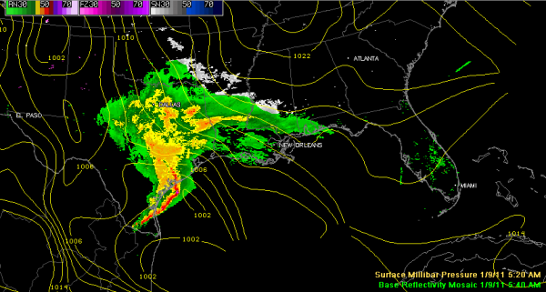
Here is the composite radar and pressure pattern at the surface. It shows the low over the western Gulf having just emerged from Mexico.
The NWS Birmingham has switched the winter storm warning for South Central Alabama to an ice storm warning. It just more clearly highlights the threat over that area. It goes from 6 p.m. today until 6 p.m. tomorrow. Here are the counties covered by that: Autauga, Barbour, Bibb, Bullock, Chambers, Chilton, Coosa, Dallas, Elmore, Greene, Hale, Lee, Lowndes, Macon, Marengo, Montgomery, Perry, Pike, Russell, Sumter and Tallapoosa.
The Winter Storm Warning continues for Blount, Calhoun, Cherokee, Clay, Cleburne, Etowah, Fayette, Jefferson, Lamar, Marion, Pickens, Randolph, Shelby, St. Clair, Talladega, Tuscaloosa, Walker and Winston.
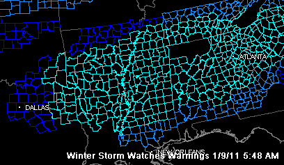
Here is the slew of winter storm watches and warnings (and ice storm warnings) in effect across the southern U.S. That hole over North Alabama is not correct. The NWS Huntsville maintains a winter storm warning for their counties as well.
NOTE FROM THE GFS
The 06z (midnight) run of the GFS was similar to the earlier run, but with a less pronounced shortwave. It really shows the low weakening as it gets into the northeastern Gulf. This could be a positive in that there would be less of a warm nose at 5,000 feet this evening, meaning more snow and less freezing rain over North Central Alabama (I-20 corridor). The NAM looked about the same. This could mean more snow and less freezing rain around I-20 but still a good chance of freezing rain further south.
We will be with it all day waiting to see the whites of its eyes…
Category: Alabama's Weather, Winter Weather


