Major Snow/Ice Event Ahead
Here is an early morning look at the winter storm headed for Alabama; Brian will be along shortly with a fresh Weather Xtreme video….
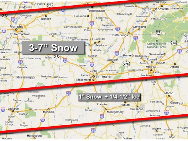
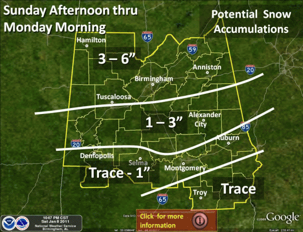
See the forecast accumulation graphics from me, and the Birmingham NWS below…
Not much difference in the snow projection… the NWS is using 3-6″ for Birmingham, Tuscaloosa, Anniston, and points north, while I am using 3-7″. The NWS Huntsville is using 4-7″ for their counties in North Alabama. I still strongly believe there will be some 8″ amounts in spots across high terrain of East and Northeast Alabama.
There will be a sharp cut-off of snow amounts south of I-20, where freezing rain will be more of a problem. Ice accumulation of 1/4 to 1/2 inch is very possible across this part of Central Alabama, and is very problematic. One-half inch of ice might sound like much, but it is enough to bring down trees and power lines, and make for widespread power outages that can last for more than 24 hours in places.
NOTE: There is little skill in determining the exact line between significant snow, and significant ice. This is the greatest challenge in this forecast. For now, the line most likely will be running a little south of Tuscaloosa, Birmingham, and Anniston, but nobody knows the exact placement at this point. Below that line is where a major ice event is likely and power outages will be an issue. Keep a close eye on updates today for adjustments to that potential snow/ice line.
The NWS has issued a winter storm warning for mostly snow for these counties: Blount, Calhoun, Cherokee, Clay, Cleburne, Etowah, Fayette, Jefferson, Lamar, Marion, Pickens, Randolph, Shelby, St. Clair, Talladega, Tuscaloosa, Walker, Winston, Franklin, Lincoln, Moore [TN] and Colbert, Cullman, De Kalb, Franklin, Jackson, Lauderdale, Lawrence, Limestone, Madison, Marshall, and Morgan.
The NWS has issued an ice storm warning for mostly freezing rain for these counties: Autauga, Barbour, Bibb, Bullock, Chambers, Chilton, Coosa, Dallas, Elmore, Greene, Hale, Lee, Lowndes, Macon, Marengo, Montgomery, Perry, Pike, Russell, Sumter, Tallapoosa.
WHEN? Precipitation is now falling over South Mississippi and extreme Southwest Alabama. More than likely, some of this is not reaching the ground, but the lower levels will saturate soon and all of this will be moving northeast. While we could see some freezing rain or snow this afternoon, the bulk of the precipitation will come from 6:00 tonight through 8:00 a.m. tomorrow. Snow and freezing rain could be heavy at times after midnight.
TRAVEL: Travel will become difficult, if not impossible, tonight and tomorrow morning due to snow and ice. Expect airport delays, and it is possible some airports will have to close for a while. In addition to Birmingham-Shuttlesworth International Airport, this storm will also impact airports at Atlanta, Nashville, and Memphis.
POWER: In the ice storm warning zone, there could be power outages due to the weight of the ice on trees and power lines. A few scattered power outages are possible over North Alabama as well due to the snow, but it should not be a widespread problem there. Review the ice storm warning counties above to see the places in greatest danger of power outages.
DON’T FORGET: With every winter weather event in Alabama…
*Some will be delighted with the amount of snow they get, others will be severely disappointed
*There will be surprises as the event unfolds.
CHAT: You can join the live chat over on the uStream live radar page here.
Again… Brian will be along shortly with the morning weather xtreme video, and we will have running updates throughout the day.
Category: Alabama's Weather, Winter Weather


