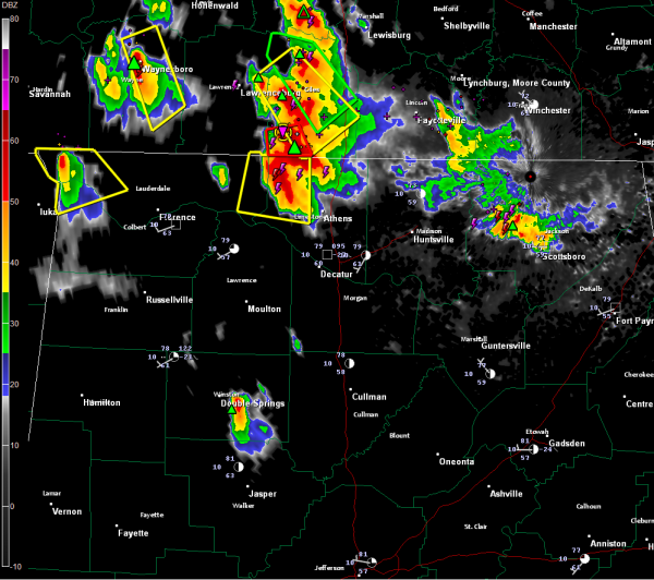
Nasty Storms in Tennessee Valley
That’s very dangerous storm approaching the Alabama/Tennessee border. It is southwest of Pulaski TN. It is moving south southeast at 30 mph. It will reach northwest Limestone County in Alabama by 4:20.
The storm’s VIL is at the top of the scale indicating very large hail. Baseball sized hail was reported just south of Pulaski.
It also shows strong signs of rotation and does show a tornado vortex signature, so the NWS maintains a tornado warning for Giles County TN.
It will continue to push south southeast, passing near or just west of Athens on its current track and eventually near Decatur or Trinity by 5-5:15.
A severe thunderstorm warning is already in effect for western Limestone and eastern Lauderdale for the same storm.
Another severe thunderstorm warning is in effect for western Lauderdale and Colbert Counties for a storm passing west of teh Shoals.
Further south, a strong storm is in Winston County. It is between Double Springs and Arley. It will push southeast into Walker County passing east of Jasper.
A severe thunderstorm watch is in effect for the Tennessee Valley til 9 p.m.
The storms will continue to push into NOrth Central Alabama, reaching as far south as Marion, Winston, Cullman and northern Etowah Counties by 6 p.m.
The storms will hold together until mid evening, likely reaching the I-20 corridor. The good news is that the survey south you go, the shear weakens and the storms will eventually die out.
Category: Alabama's Weather, Severe Weather


