Hot May Weekend Ahead
**No afternoon Weather Xtreme video today**
THIS AFTERNOON: As expected, morning clouds have given way to a partly sunny afternoon across Alabama with temperatures generally in the mid 80s. The only showers across the state are down in Barbour County in Southeast Alabama.
OUR WEEKEND: Not much change in our forecast thinking… see the morning Weather Xtreme video for details. Look for a high in the 87 to 90 degree range tomorrow and Sunday with a mix of sun and clouds each day. There will be enough moisture for scattered, mostly afternoon and evening showers and thunderstorms both days. The chance of any one spot getting wet is about one in three, and most of the storms will come from 2:00 p.m. until 7:00 p.m. However, we will have to watch for thunderstorms areas northwest of Alabama; those will move to the southeast and can often bring a surprise in this pattern with a ridge to the west and a weak northwest flow aloft with occasional weak ripples of energy moving through the flow.
AARON’S DREAM WEEKEND: The weather will be very warm at Talladega this race weekend, with highs between 87 and 90 degrees each day over the weekend. A few showers and storms will be popping up in scattered spots during the afternoon and evening hours; the chance of a storm at the Superspeedway is in the 30 percent range tomorrow and Sunday. If a storm does drift over the track, the rain shouldn’t last more than 30 minutes or so. You will need sunscreen.
AT THE BEACH: Expect partly sunny days, and fair nights along the coast from Panama City west to Gulf Shores. A few widely scattered showers are possible each day, but rain won’t be a big issue through early next week with about 7 to 9 hours of sunshine each day. Highs will be in the 80s, and the sea water temperature at the Dauphin Island Sea Lab early this morning was 77 degrees.
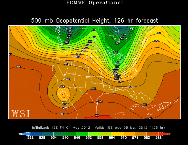
NEXT WEEK: Expect scattered to numerous showers and storms Monday and Tuesday, followed by a nice surge of cooler and drier Wednesday through Friday as an upper trough forms over the eastern third of the nation. Highs will drop into the 70s, with lows in the 50s. Cooler spots should reach the 40s early Thursday and Friday morning as continental air will cover the Deep South. See the ECMWF depiction of the upper air flow at 500 mb next Wednesday…
WEATHER BRAINS: Don’t forget you can listen to our weekly 90 minute netcast anytime on the web, or on iTunes. This is the show all about weather featuring many familiar voices, including our meteorologists here at ABC 33/40.
CONNECT: You can find me on all of the major social networks…
I had a great time today visiting with the kids at Thorsby Elementary School in Chilton County… look for them on the Pepsi KIDCAM today at 5:00 on ABC 33/40 News! Brian Peters will have the video updates tomorrow and Sunday… my next Weather Xtreme video will be posted bright and early Monday morning by 7:00 a.m. Enjoy the weekend!
Category: Alabama's Weather


