Interesting dynamics
Strong upper-level low slowly approaching Alabama tonight, as cold air moves in from the west. We normally talk about two ways of producing precipitation, bringing in warm air (which is not happening here), or bringing in an upper-level disturbance. That is occurring. Take a look at the latest 500 mb chart from SPC.

You see the main upper-level disturbance moving NE along the MS/AL border. However, there is another disturbance in Oklahoma and Kansas, that may enhance the precipitation again later tonight.
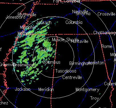
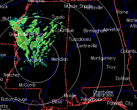
Radars from Jackson and Columbus, MS tonight indicate that the bulk of the precipitation is moving NNE, toward NW Alabama and middle TN. This, by itself, is not encouraging for snow in BHM. However, with the upper-level disturbance moving in, new areas of precipitation are developing in Alabama over the past hour, as far east as Jasper. This trend will likely continue this evening, and with temperatures falling, we may start out with rain, then change over to snow by 9 pm in Jasper and by 11 pm in BHM.
Another interesting thing to note is that new areas of snow are also forming behind the main area, west of Jackson, MS. These could be associated with the next disturbance coming out of Oklahoma. This is encouraging.
Finally, with upper-level temperatures becoming so cold overnight, the air aloft will become somewhat unstable. So, we may actually see a few weak thunderstorms, which will make snow amounts vary widely from place to place. Some of the areas east of Memphis, where some thunder was reported over the past few hours and heavy snow, have the unstable air in place now. The chart below shows the temperature change between 700 and 500 mb (10,000 and 18,000 feet).

This is still a rapidly developing event, and how much snow falls in areas such as Tuscaloosa, Birmingham, and Montgomery may depend somewhat on the secondary system, and somewhat on just how cold the air aloft can get, promoting instability. The 1″ in BHM would be an average…some spots may see 2″, others may only get a dusting. It may also be that, with the exception of the higher elevations in NE Alabama, the higher snow amounts are west of I-65.
Category: Uncategorized
About the Author (Author Profile)
Subscribe
If you enjoyed this article, subscribe to receive more just like it.


