One More Dry Day
**A reminder there won’t be an afternoon Weather Xtreme video today…**
WARM AND DRY TOMORROW: No rain in radar across the northern half of Alabama this afternoon, and temperatures are generally in the mid 80s at mid-afternoon. The sky is partly sunny, and humidity values remain rather low.
Tomorrow will be another warm, dry day with a high in the mid to upper 80s.
RAIN RETURNS OVER THE WEEKEND: The well defined upper low near the Texas/Oklahoma border will move southeast toward the Gulf Coast over the next 48 hours, and will bring rain back to Alabama and the Deep South over the weekend. Scattered showers and storms will begin to fire up Saturday afternoon: the chance of any one spot getting wet is about 50/50 by Saturday evening.
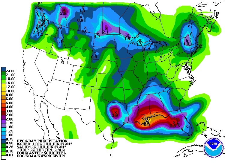
The rain will be more widespread on Sunday as the upper low gets closer, and moisture levels continue to rise. Looks like we will need to mention a chance of locally heavy rain Sunday and Monday, with rain totals possibly exceeding two inches. See the five day QPF chart below…
With a weak front approaching from the north, looks like we can expect numerous showers and storms into Tuesday and Wednesday. A really good chance to pick up some beneficial early summer rain without a tropical system involved.
See the morning Weather Xtreme video for more details. Will be live on ABC 33/40 at 5 and 6 from the Regions Charity Golf Classic at Shoal Creek…. Look for the next Weather Xtreme video here by 7:00 a.m. tomorrow….
Category: Alabama's Weather
About the Author (Author Profile)
James Spann is one of the most recognized and trusted television meteorologists in the industry. He holds the AMS CCM designation and television seals from the AMS and NWA. He is a past winner of the Broadcast Meteorologist of the Year from both professional organizations.Subscribe
If you enjoyed this article, subscribe to receive more just like it.


