Hottest Weather Since 2007
The hottest temperatures since the heat wave of 2007 are impacting Alabama now. There are some signs that the current heat wave will back off just a bit after Monday as moisture levels increase a bit and temperatures ease just a tad. Through then, highs will range between 99F-101F from Montgomery to Clanton to Columbus GA. Further northwest, highs will be between 102F-105F.
The good news is that the humidity levels are not as high as they could be, so heat index values will generally remain between 105F-109F. This is heat advisory criteria. When it crosses 110F, an excessive heat warning is warranted.
An advisory means hot weather, but conditions are generally short of dangerous levels without prolonged exposure.
FRIDAY HIGHS: Yesterday was a scorcher across Central Alabama. Highs included 105F at the Shelby County Airport and Tuscaloosa, and 103F at Birmingham and 102F at Anniston. It was 107F at Muscle Shoals and 106F at Huntsville.
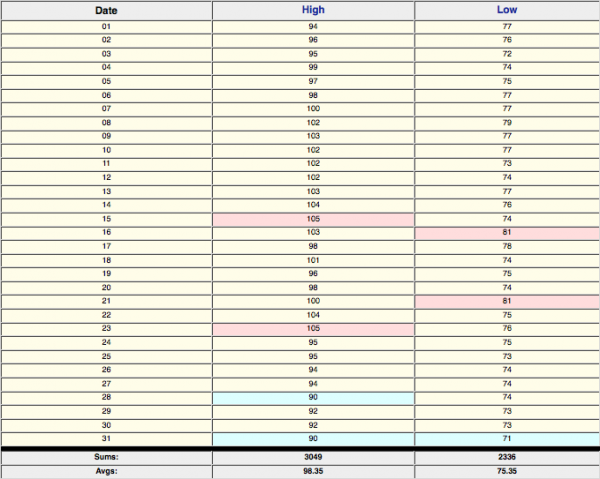
REMEMBERING THE 2007 HEAT WAVE: A strong ridge of high pressure in August produced a record setting heat wave. The sizzling heat began in earnest on August 4th, when several observationa stations hit the century mark or higher. The heat would reach its peak between the 10th and 15th with multiple high temperature marks between 105F and 109F. Daily temperature records were broken or tied on 11 days in Anniston, 10 days in Birmingham, 12 days in Montgomery and 14 days in Tuscaloosa. All four stations broke or tied their all-time August record highs. The 107F at Pinson on the 15th is the hottest ever there. It reached 109F at Hamilton on the 15th. 107F at Muscle Shoals on the 15th is their hottest ever. The mercury hit 100F at Birmingham for ten consecutive days between the 7th and 16th. The mercury reached 100F or higher on 14 days during the month, tying for second all time in Birmingham and just one short of the all time record set in 1925. A total of 14 people died in Alabama as a result of the heat wave. It was the hottest month ever recorded in Birmingham (86.9F.)
NO MAJOR RAIN RELIEF IN SIGHT: That crunching sound you hear is the sound of lawns drying up in this parching heat and lack of rainfall. All of central Alabama is now in dire need of short term moisture. Unfortunately, there aren’t any real rain chances in sight. Saturday’s rain chances are basically nil. Sunday, there could be enough moisture in the atmosphere to scare up one or two isolated storms. Same for Monday. Rain chances will be about 1 in 5 for the rest of the work week.
AIR QUALITY ALERT: Jefferson and Shelby Counties continues under a Code Orange Air Quality Alert for ozone. There are a few things that you can do to cut down on ozone as a pollutant. Carpool or take mass transit. Avoid unnecessary trips if you must drive. Avoid mowing the lawn. Don’t do any outdoor burning. Fueling your car also contributes to the problem, so avoid filling your tank until after 6 p.m.
Category: Alabama's Weather


