

Dramatic Temperature Changes
Click image to enlarge.
Let’s take a trip down I-20 early this afternoon toward Texas for a study in contrasts. By the time you get to Tuscaloosa, temperatures are in the 70s. They stay that way until Jackson, Mississippi. It’s only a short distance, around 50 miles, from Jackson to Vicksburg, but by the time you cross the Mississippi River there, temperatures are in the 50s. Get To Monroe, Louisiana, and it’s 45F. By the time you pass Shreveport and get into East Texas, it’s 35F at Tyler.
To further illustrate the dramatic contrast in the two airmasses on either side of the boundary, let’s look at what happened at Vicksburg between 9 and 10 a.m. At 9 o’clock, it was 71F with partly cloudy skies and a balmy south wind averaging 13 mph. One hour later, those southerly winds had become northwesterly, averaging 18 mph and gusting all the way to 38 mph. The temperature had plunged 16 degrees in less than an hour. Actually, the temperature drop occurred in 24 minutes. By 1 o’clock it was down to 46F with a thunderstorm in progress.
That’s what is on our way.
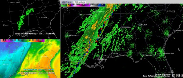
All this means rain, and a good bit of it, over the next 60 hours or so across Alabama as the front makes only grudging progress to the east. By tonight, it will be near I-59, delivering some of those impressive temperature changes to places like Gadsden, Birmingham and Tuscaloosa. Ahead of the front, showers were increasing over South Central Alabama at early afternoon. That trend should continue until the front arrives this evening, and after that you can expect periods of rain through Tuesday.
The heaviest rain looks like it will be in the I-59 corridor now, where 3 to 4 inches of rain could call between now and Wednesday. There is a flash flood watch now for the western counties of the Tennessee Valley in Alabama, but for now, no flash flood watches for Central Alabama. Flash flood warnings were starting to pile up over the Mississippi Delta Counties to our west by early afternoon, however.
After today’s highs that are flirting with or in the 70s, highs will be limited to the 40s Monday through Wednesday. Low will be in the midlde40s tonight, lower 40s tomorrow night and near 40F Wednesday morning.
Category: Alabama's Weather
About the Author (Author Profile)
Bill Murray is the President of The Weather Factory. He is the site's official weather historian and a weekend forecaster. He also anchors the site's severe weather coverage. Bill Murray is the proud holder of National Weather Association Digital Seal #0001 @wxhistorianSubscribe
If you enjoyed this article, subscribe to receive more just like it.


