

Gusty Winds Ahead of Storms
The surface winds continue to increase across the area. Winds are gusting to 30-40mph out ahead of the main batch of storms. A wind advisory is being issued for the area as strong winds are capable of producing some tree damage.
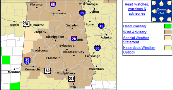
...WIND ADVISORY IN EFFECT UNTIL 8 AM CDT FRIDAY...

THE NATIONAL WEATHER SERVICE IN BIRMINGHAM HAS ISSUED A WIND
ADVISORY...WHICH IS IN EFFECT UNTIL 4 AM CDT FRIDAY.

* TIMING...OF THE STRONGEST WINDS WILL BE THROUGH 4 AM. WINDS WILL
  DISSIPATE TO BELOW CRITERIA ONCE THE FRONT WORKS THROUGH.

* WINDS...WILL BE SUSTAINED AT 15 TO 20 MPH WITH GUST OF 30 TO 40
  MPH AT TIMES.

PRECAUTIONARY/PREPAREDNESS ACTIONS...

A WIND ADVISORY MEANS THAT SUSTAINED WINDS OF 24 MPH AND HIGHER...
OR WIND GUSTS OF 36 MPH AND HIGHER...ARE EXPECTED. WINDS THIS
STRONG CAN MAKE DRIVING DIFFICULT...ESPECIALLY FOR HIGH PROFILE
VEHICLES. USE EXTRA CAUTION.
Storms continue to move across West Alabama. The most intense activity is affecting Fayette County and is now pushing into portions of Walker County as well as northern Tuscaloosa County and then back to the west in Pickens County. Heavy rain, strong winds and frequent lightning can occur within these thunderstorms.

Category: Alabama's Weather, Severe Weather
About the Author (Author Profile)
Macon, Georgia Television Chief Meteorologist, Birmingham native, and long time Contributor on AlabamaWX. Stormchaser. I did not choose Weather, it chose Me. College Football Fanatic. @Ryan_StinnetSubscribe
If you enjoyed this article, subscribe to receive more just like it.


