

Lunchtime Radar Check
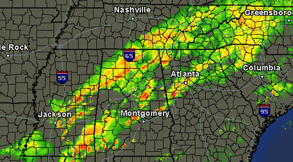
The cold front responsible for the showers and thunderstorms is making its way into northwest Alabama. A line of thunderstorms has developed along this boundary and the storms continue to propagate northeast along the front as it drops south.
Behind the front, the rain is beginning to taper off in Lauderdale, Colbert and Franklin Counties in northwest Alabama. Some of the most intense activity is stretching from Cullman, down through Jasper, Fayette and Reform. No storms are currently severe, but there are some strong storms in the line. The storms could produce gusty winds, some hail and torrential rains. Watch out for dangerous lightning as well. This line will be approaching Birmingham and Tuscaloosa within the next hour.
Out ahead of the main line, showers and strong thunderstorms have developed around Prattville, Talladega, and Rockford. These storms could be producing some small hail and gusty winds as well. The threat for showers and thunderstorms will continue through the rest of the afternoon in many locations until the front clears.
Category: Alabama's Weather
About the Author (Author Profile)
Macon, Georgia Television Chief Meteorologist, Birmingham native, and long time Contributor on AlabamaWX. Stormchaser. I did not choose Weather, it chose Me. College Football Fanatic. @Ryan_StinnetSubscribe
If you enjoyed this article, subscribe to receive more just like it.


