Worst Weather to the South
Over the last few hours, the worst of the weather has been drifting to the south. Heavy rain continues to be the main threat with the showers and thunderstorms that are ongoing across Central Alabama. For areas along and north of Interstate 20, the rain has tapered off and we are drying out some.
The worst of the weather in along Interstates 85 and 65. Driving conditions are not favorable at all right now as gusty winds and torrential tropical rains are falling. I expect several more flash flood warnings to be issued with the line of activity during the overnight hours. Rainfall rate could be 1-3 inches easily with some areas possibly picking up 4-5 inches.
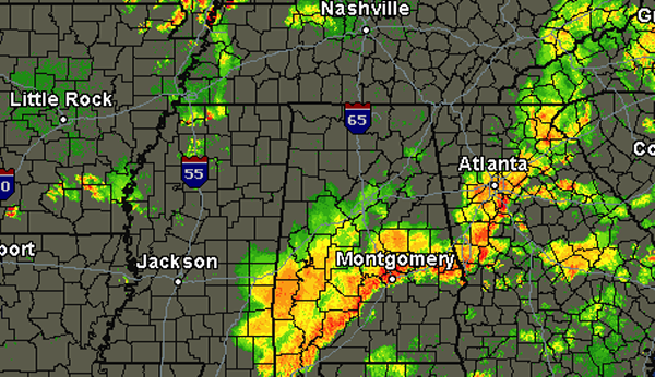
For the next few hours, we will be watching this complex of showers and storms. We are also watching some thunderstorms that are working there way down from the Memphis area too. These storms have had a history of being severe, including a few tornado warnings with them. Hopefully these storms will continue to weaken over the next few hours, but if they hold together they could be impacting some of our counties during the early morning hours. Just something to keep in mind for the overnight hours.
Category: Alabama's Weather, Severe Weather
About the Author (Author Profile)
Macon, Georgia Television Chief Meteorologist, Birmingham native, and long time Contributor on AlabamaWX. Stormchaser. I did not choose Weather, it chose Me. College Football Fanatic. @Ryan_StinnetSubscribe
If you enjoyed this article, subscribe to receive more just like it.


