

Showers and Storms Today
Saturday was a pretty descent day across the our part of the state. Most locations stayed dry and humidity levels were low. A few showers and storms made their way into our southern counties but nothing too intense. Today will be much different as widespread showers and thunderstorms are expected.
OUR WEATHER STORY: A frontal boundary that has been stalled across our southern counties for a couple of days is beginning to lift north as a warm front. Southerly flow with this feature is bringing a return of a deep layer of moisture across the region. This moisture will be the fuel for showers and storms that develop today. The front and several upper-level features will provide enough uplift to allow for showers and thunderstorm to develop this morning and through out the afternoon and evening. The unsettled weather will last for the next 24-36 hours.

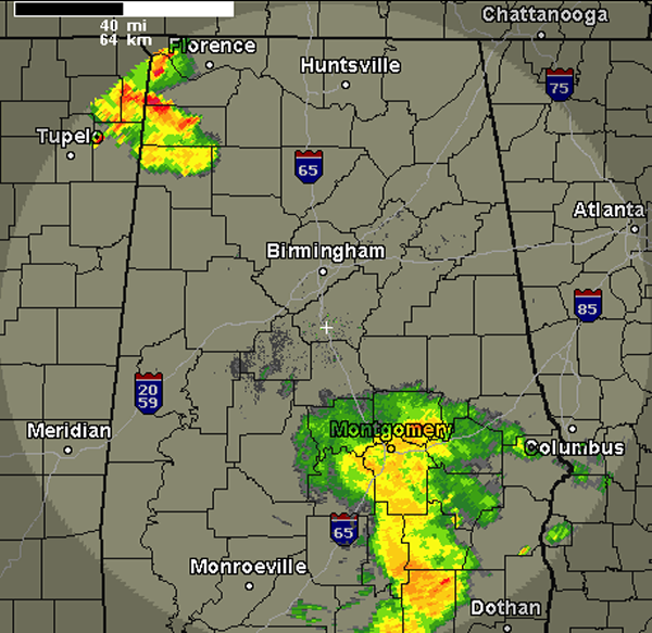
RADAR CHECK: Most areas are dry this morning. We have had several storms move across portions of Lamar and Marion Counties, but this activity has since moved north into the Tennessee Valley. Back to our southeast, rain is falling around the Montgomery area, but as it moves north it is loosing some of its punch. We can expect the radar to fill in later today, severe weather is not expected, but we will have to watch areas for some isolated flash flooding.
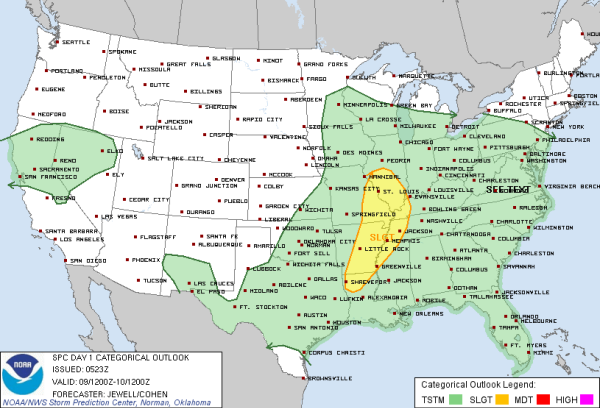
SEVERE WEATHER OUTLOOK: The SPC has issued a slight risk for severe weather today along the Mississippi River from northern Louisiana to Central Illinois. This risk includes the cities of Little Rock, Memphis, St. Louis. Storms are expected to develop later this afternoon along the cold front that is dropping southeast today. Hail and damaging winds are the main concerns as bowing segments in a line of thunderstorm could produce high winds. Tornado threat is rather low across the risk area.
CENTRAL ALABAMA NWA CHAPTER: Excitement is building as we are rapidly approaching our next chapter meeting. On June 20th, the chapter will have two meetings. The first meeting will be in Montgomery at 1PM, the second meeting will be in Birmingham that evening. Our guest speaker at both meetings will be Dr. Bill Read, former Director of the National Hurricane Center. He will have presentations on tropical weather and provide his expertise on hurricanes. I am sure we will not even scratch the surface of his vast knowledge and wisdom on tropical weather, but it certainly will be a treat for anyone in attendance just to hear the snip-its we will receive. You can keep up with all the happenings of the chapter by clicking Here
WHAT TO EXPECT TODAY: As expected some areas are seeing showers and thunderstorms this morning. As we head through the rest of the day and as moisture levels rise due to frontal passage, expect showers and thunderstorms to expand in coverage today. We will see more clouds than sun today, and with the ample moisture and lift, not much daytime heating will be needed to get additional development. Most ares could see anywhere from one half inch to an inch or rain. Some areas could see higher rain fall totals as these are tropical downpours with these storms. Be mindful of an isolated flash flooding threat. Showers and storms will look to last through the evening and overnight. We can expect more unsettled weather on Monday, before we finally begin to get a chance to dry out on Tuesday. Afternoon highs will be a held down as we have the increase in clouds and moisture, most areas will only see lower 80s today.
WARMING UP AND DRYING OUT: As the rain moves out on Tuesday, we look to have a few days in a row of dry conditions. With the drier conditions the heat will be on as well. We will be looking at the warmest afternoon highs so far for 2013. Most locations will see afternoon highs in the 90s and we could even see some mid 90s this week. Some scattered showers are possible late in the week as another front approaches the state.
Category: Alabama's Weather
About the Author (Author Profile)
Macon, Georgia Television Chief Meteorologist, Birmingham native, and long time Contributor on AlabamaWX. Stormchaser. I did not choose Weather, it chose Me. College Football Fanatic. @Ryan_StinnetSubscribe
If you enjoyed this article, subscribe to receive more just like it.


