

Severe Thunderstorm Warning St. Clair Co. til 6:45

UPDATE 6:40
Storm appears to be collapsing now as it crosses US-231 between Wattsville and Pell City. Damaging winds are possible in this area. Be alert.
ORIGINAL POST
A strong thunderstorm is just north of I-20 between Odenville and Pell City. It is moving northeast toward Wattsville.
From Twitter: @spann Its hailing marble sized in argo on cty line, rain so hard cant see out window & lighting awful.
Kelli Walker posted this picture of a tree down on US-411 in Odenville:

Hail up to an inch, torrential rains and deadly lightning are likely with the storm, as well as winds of 60 mph.
The warning includes the Coosa River around Neely Henry Dam. Lake Logan Martin is not included, but lightning is close enough to warrant getting off the water.
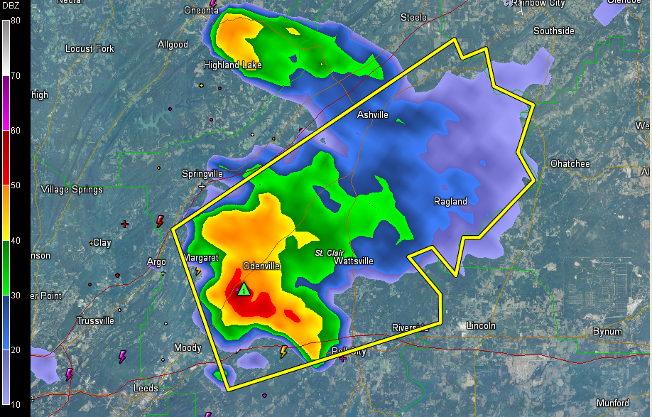
THE NATIONAL WEATHER SERVICE IN BIRMINGHAM HAS ISSUED A
* SEVERE THUNDERSTORM WARNING FOR…
CENTRAL ST. CLAIR COUNTY IN ALABAMA…
* UNTIL 645 PM CDT
* AT 559 PM CDT…THE NATIONAL WEATHER SERVICE INDICATED A SEVERE
THUNDERSTORM CAPABLE OF PRODUCING QUARTER SIZE HAIL…AND DAMAGING
WINDS IN EXCESS OF 60 MPH. THIS STORM WAS LOCATED NEAR
BRANCHVILLE…OR NEAR ODENVILLE…AND MOVING EAST AT 25 MPH.
* LOCATIONS IMPACTED INCLUDE…
RIVERSIDE…ASHVILLE…RAGLAND…ST. CLAIR SPRINGS…WATTSVILLE…
NEELY HENRY DAM AND WILLIAMS.
THIS INCLUDES…
INTERSTATE 20 EXIT NUMBERS 152 THROUGH 158…
Category: Alabama's Weather, Severe Weather
About the Author (Author Profile)
Subscribe
If you enjoyed this article, subscribe to receive more just like it.


