Risk for Severe Weather and a Possible Watch Today
Over the last few hours we have been monitoring a complex of showers and thunderstorms drop south out of Tennessee, cross Mississippi and are now affecting some of our northwestern counties. Though the storms have weakened some over the last few hours, we are expecting some intensification this afternoon. This complex of storms will continue to drop southeast over the next few hours.
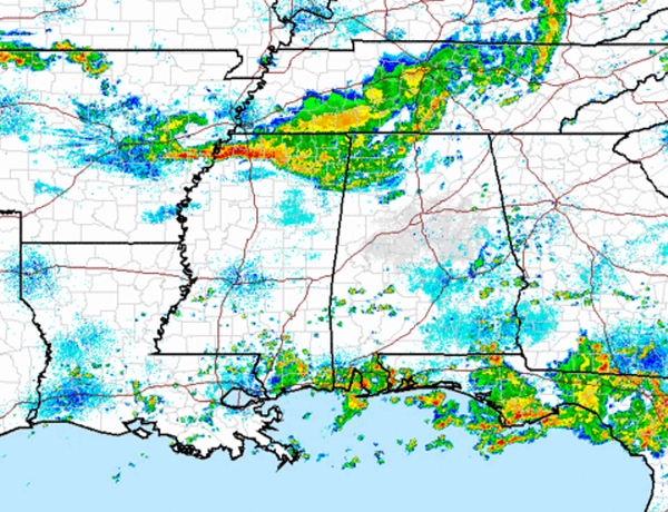
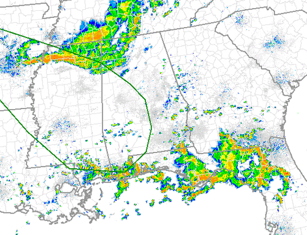
In the latest day one convective outlook, the SPC has issued their standard “slight” risk for severe weather for portions of West and Southwest Alabama. The risk does not include Birmingham, Cullman, Gadsden or Anniston, but does include Tuscaloosa. Areas from near Hamilton, down into extreme western Jefferson County to Clanton, Prattville and down towards the Gulf Coast are included. Locations west of this line have been included in the risk as outlined in green below. Other cities included are Fayette, Demopolis, Livingston, Selma, Eutaw, Grove Hill and Mobile. Damaging winds are the greatest threat, but hail may be possible as well. We will certainly be watching for a flash flooding threat as these storms will be dropping copious amounts of rain and we have to watch out for the tremendous amounts of lightning these storms are producing.
The SPC did issue a MCD a little while ago and have given portions of Alabama a 40% chance of seeing a severe weather watch today. The SPC and local NWS offices are carefully monitoring conditions and will coordinate with each other if the watch is needed.

AREAS AFFECTED…SERN AR…NRN/CNTRL MS…NWRN/W-CNTRL AL
CONCERNING…SEVERE POTENTIAL…WATCH POSSIBLE
VALID 221604Z – 221730Z
PROBABILITY OF WATCH ISSUANCE…40 PERCENT
SUMMARY…LINE OF STORMS LOCATED FROM NWRN AL INTO NRN MS AND
E-CNTRL AR MAY DEVELOP INTO A FORWARD PROPAGATING MCS BY MIDDAY. IF
THIS OCCURS…THREAT FOR DAMAGING WINDS WILL INCREASE ACROSS THE
AREA…AND WW MAY BECOME NECESSARY. IN ADDITION…SLGT RISK WILL BE
INTRODUCED WITH THE 16Z DAY 1 CONVECTIVE OUTLOOK.
DISCUSSION…LATE MORNING MESOANALYSIS DEPICTED A COMPOSITE OUTFLOW
BOUNDARY EXTENDING WWD FROM NWRN AL ACROSS NRN MS AND THEN WNWWD
INTO AR. RADAR TRENDS INDICATE NEW STORM DEVELOPMENT HAS GENERALLY
OCCURRED ATOP THE COLD POOL DURING THE EARLY TO MID MORNING HOURS.
HOWEVER…NEW STORMS APPEAR TO BE FORMING ALONG THE LEADING EDGE OF
THE COLD POOL DURING THE LAST HOUR OVER NRN MS. AS THE BOUNDARY
LAYER CONTINUES TO WARM AND DESTABILIZE FROM SERN AR EWD ACROSS MS
INTO W-CNTRL AL…COLD POOL AND DEEP CONVECTION ALONG ITS LEADING
EDGE MAY SURGE SSEWD…POSSIBLY AIDED BY MIDLEVEL VORT MAX LOCATED
OVER THE OZARKS AT 16Z. AREA VWP/S SHOW 30 KT OF DEEP-LAYER WNWLY
FLOW RESIDES ACROSS THE REGION…WHICH MAY BE SUPPORTIVE OF AN
ORGANIZED FORWARD PROPAGATING MCS GIVEN EXPECTED MODERATE TO STRONG
INSTABILITY BY EARLY AFTERNOON. CONVECTIVE TRENDS WILL CONTINUE TO
BE MONITORED FOR THIS POTENTIAL EVOLUTION…AT WHICH POINT A WW MAY
BECOME NECESSARY.
Category: Alabama's Weather, Severe Weather
About the Author (Author Profile)
Macon, Georgia Television Chief Meteorologist, Birmingham native, and long time Contributor on AlabamaWX. Stormchaser. I did not choose Weather, it chose Me. College Football Fanatic. @Ryan_StinnetSubscribe
If you enjoyed this article, subscribe to receive more just like it.


