

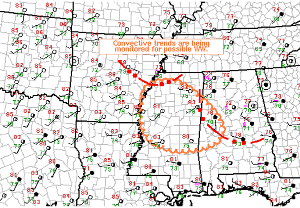
Possible Watch for Portions of Alabama
The last few hours have seen instability increase in the wake of this mornings activity. As daytime heating continues, additional showers and thunderstorms are expected to develop across much of Alabama. Multiple outflow boundaries across the area as well as several upper-level features will be providing uplift for the very moisture rich atmosphere in place across the state. The SPC has issued a MCD for sections of West Alabama. There is a 40% chance that a severe weather watch may be needed as we head through the day. If a watch is needed, the local NWS offices and SPC will coordinate with each other on the exact location of the possible watch.
No matter if a watch is issued or not, all of northwest Alabama remain in a slight risk for severe weather today. Thunderstorms will be strong today and will produce tremendous amounts of lightning, very heavy rainfall, gusty winds and hail. Flash flooding will remain our greatest concern with today’s convection.
AREAS AFFECTED…NRN/CNTRL MS…W-CNTRL AL
CONCERNING…SEVERE POTENTIAL…WATCH POSSIBLE
VALID 231504Z – 231630Z
PROBABILITY OF WATCH ISSUANCE…40 PERCENT
SUMMARY…CLUSTER OF STORMS OVER NRN MS IS BEING MONITORED FOR
UPSCALE GROWTH INTO A FORWARD PROPAGATING MCS AND INCREASING
DAMAGING WIND POTENTIAL. WW IS POSSIBLE.
DISCUSSION…RADAR IMAGERY AT 1445Z SHOWED A CLUSTER OF
THUNDERSTORMS MOVING ESEWD AT 40 KT OVER NRN MS…WHILE A SECOND
COLD POOL AND ASSOCIATED CONVECTION WAS SURGING SWD OVER FAR NWRN MS
AND E-CNTRL AR. ANOTHER AREA OF CONVECTION WAS ALSO MOVING EWD OVER
NRN/CNTRL AL…AND HAS LEFT AN OUTFLOW BOUNDARY IN ITS WAKE FROM
ROUGHLY CBM SEWD TO 20 N OF TOI.
MEANWHILE…CLEAR SKIES OVER CNTRL MS COMBINED WITH WLY LOW-LEVEL
FLOW IS AIDING IN STRONG SURFACE HEATING. THE DESTABILIZING BOUNDARY
LAYER AIRMASS COMBINED WITH LOW TO MID 70 DEWPOINTS IS YIELDING
MLCAPE VALUES FROM 1500-2500 J/KG. THIS AIRMASS WILL CONTINUE TO
SUPPORT ADDITIONAL STORM DEVELOPMENT AS THE COLD POOL OVER NRN MS
MOVES SWD INTO CNTRL MS AND W-CNTRL AL. AS THIS TAKES
PLACE…UPSCALE GROWTH INTO A FORWARD PROPAGATING MCS AND SUBSEQUENT
INCREASE IN DAMAGING WIND POTENTIAL MAY OCCUR…AND COULD
NECESSITATE THE NEED FOR A WW.
Category: Alabama's Weather, Severe Weather
About the Author (Author Profile)
Macon, Georgia Television Chief Meteorologist, Birmingham native, and long time Contributor on AlabamaWX. Stormchaser. I did not choose Weather, it chose Me. College Football Fanatic. @Ryan_StinnetSubscribe
If you enjoyed this article, subscribe to receive more just like it.


