

Strong Storms Developing
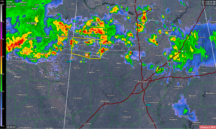
Numerous showers and storms are beginning to develop across Central Alabama, especially over northwestern portions of the state. The radar is lighting up as updrafts are tapping into a very rich moisture field, providing ample fuel for this convection. Dew points in many locations are in the upper 70s and precipitable water values are in excess of two inches.
These storms are capable of producing gusty winds and hail. Frequent lightning as well as tropical downpours are being reported. Flash flooding is a serious threat today. Portions of Franklin County radar estimates are over 4 inches of rain have fallen. Flash flooding is being reported around Russellville. With the storms over northwest Alabama pea size hail is being reported around Guin and Hamilton.
In eastern areas of the state, Gadsden and Anniston are seeing heavy rain as well, but these storms have been weakening over the last few hours. However, water has been reported over several roads in East Alabama.
We are expecting additional storms to develop as we head through the day as a short wave trough over northern Mississippi enters western Alabama. It will continue to move east-southeast across the state and we are expecting most areas to receive very heavy rainfall today. Storms will be impacting the Birmingham area over the next few hours.
Category: Alabama's Weather
About the Author (Author Profile)
Macon, Georgia Television Chief Meteorologist, Birmingham native, and long time Contributor on AlabamaWX. Stormchaser. I did not choose Weather, it chose Me. College Football Fanatic. @Ryan_StinnetSubscribe
If you enjoyed this article, subscribe to receive more just like it.


