

Storms Persist this Evening
This seemingly unending bombardment of showers and storms in Alabama continues again this evening. Multiple locations are once again seeing heavy rain and storms.
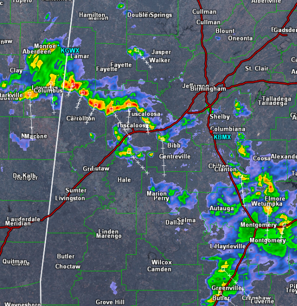
Currently the more intense storms are over western portions of Alabama. A line of storms from Columbus, Mississippi to northeast of Tuscaloosa are experiencing some intense storms. Lightning, heavy rain and gusty winds are occurring in this line. None of these storms are severe at the moment, but they could pulse up and reach severe limits briefly. The line will be dropping south and will be impacting Tuscaloosa, Northport, Gordo and Reform. Some of the major roadways to be more cautious on this evening are Interstate 20/59, highways 82, 69 and 43. Flash flooding will be our main concern the next few hours.
Elsewhere across Central Alabama, several showers and storms are along and just east of Interstate 65 in Shelby County and extend down south of Montgomery. All activity will persist for several more hours and we could continue to see additional development as well
A frontal boundary is slowly dropping south into Alabama and it should provide some rain relief over the next couple of days as dry air moves in behind it.
Category: Alabama's Weather
About the Author (Author Profile)
Macon, Georgia Television Chief Meteorologist, Birmingham native, and long time Contributor on AlabamaWX. Stormchaser. I did not choose Weather, it chose Me. College Football Fanatic. @Ryan_StinnetSubscribe
If you enjoyed this article, subscribe to receive more just like it.


