Latest Advisory on Karen
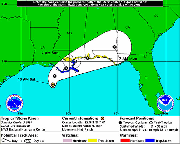
Karen maintains tropical storm strength, but is likely to be downgraded to a depression later today. Karen remains very unorganized with the center of circulation nearly 100 miles from the deepest thunderstorm convection. No real change in the system except for location. Karen made a quick jog to the north-northwest, but has since turned to the north. This has shifted the track to the west some and now Karen is expected to make landfall in southeastern Louisiana later tonight. By then, she will begin to be impacted by the long wave trough digging into the eastern half of the U.S. and this will cause her to turn and accelerate to the northeast.
After crossing Louisiana, she should emerge back into the Mississippi Sound and make a secondary landfall around Mobile Bay Sunday evening. Rip current threats remain high along the Gulf Coast today as well as wave heights are higher than normal. With the system weakening, impacts may not be as bad. However, heavy rain and windy conditions are still expected to impact the north-central Gulf Coast the next couple of days.
SUMMARY OF 1000 AM CDT…1500 UTC…INFORMATION
———————————————–
LOCATION…27.9N 91.7W
ABOUT 130 MI…205 KM SSW OF MORGAN CITY LOUISIANA
ABOUT 180 MI…285 KM WSW OF THE MOUTH OF THE MISSISSIPPI RIVER
MAXIMUM SUSTAINED WINDS…40 MPH…65 KM/H
PRESENT MOVEMENT…N OR 355 DEGREES AT 7 MPH…11 KM/H
MINIMUM CENTRAL PRESSURE…1008 MB…29.77 INCHES
Category: Alabama's Weather, Tropical
About the Author (Author Profile)
Macon, Georgia Television Chief Meteorologist, Birmingham native, and long time Contributor on AlabamaWX. Stormchaser. I did not choose Weather, it chose Me. College Football Fanatic. @Ryan_StinnetSubscribe
If you enjoyed this article, subscribe to receive more just like it.


